Harrisburg geodata
Harrisburg (Pennsylvania) is a seat of a first-order administrative division; located in United States in America/New_York (GMT-4) time zone. With population of 49,081 people, there are 975 cities with bigger population in this country. Compared to other cities in United States, 56.3% of cities are located further ↓South; 81.1% of cities are located further ←West and 69.2% of cities have higher elevation than Harrisburg. Note1
Administrative division(s):
- Level 1: Pennsylvania
- Level 2: Dauphin County
- Level 3: City of Harrisburg


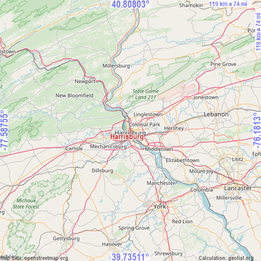
Harrisburg GPS coordinates[2]
40° 16' 25.32" North, 76° 53' 3.912" West
| Map corner | latitude | longitude |
|---|---|---|
| Upper-left | 40.80803°, | -77.58755° |
| Center: | 40.2737°, | -76.88442° |
| Lower-right: | 39.73511°, | -76.1813° |
| Map W x H: | 119.3×119.3 km | = 74.1×74.1mi |
| max Lat: | 71.29058° ⇑43.7% North |
| Harrisburg: | 40.2737° |
| min Lat: | ⇓56.3% South 19.06759° |
| min Long | Harrisburg | max Long |
| -171.73463° | -76.88442° | -66.98998° |
| W 81.1%⇐ | ⇒18.9% E |
Elevation
Elevation of Harrisburg is 105 m = 344 ft, and this is 189.8 m = 623 ft below average elevation for this country.
| Max E: |
3189 m = 10463 ft | 69.2% |
| Avg. | 294.8 m = 967 ft | |
| Harrisburg | 105 m = 344 ft | |
Min E: |
-60 m = -197 ft | 30.8% |
See also: Harrisburg elevation on elevation.city.
Geographical zone
Harrisburg is located in North temperate zone (between Tropic of Cancer and the Arctic Circle). Distance of this Northern Tropic circle is 1872.1 km =1163.3 mi to South.| Distance of | km | miles | from Harrisburg |
|---|---|---|---|
| North Pole | 5529 | 3435.6 | to North |
| Arctic Circle | 2923.2 | 1816.4 | to North |
| Tropic Cancer | 1872.1 | 1163.3 | to South |
| Equator | 4478 | 2782.5 | to South |


Nearby cities:
15 places around Harrisburg: (largest is in red/bold)
• Camp Hill
4.8 km =3 mi,  218°
218°
• Colonial Park
7 km =4.3 mi,  64°
64°
• Enhaut
6.7 km =4.2 mi,  133°
133°
• Enola
4.6 km =2.9 mi,  293°
293°
• Lemoyne
3.7 km =2.3 mi,  192°
192°
• Lower Allen
5.4 km =3.4 mi, 194°
• New Cumberland
4.6 km =2.9 mi,  180°
180°
• New Market
6.3 km =3.9 mi,  154°
154°
• Oberlin
6.9 km =4.3 mi,  121°
121°
• Paxtang
4.7 km =2.9 mi,  110°
110°
• Penbrook
3.1 km =1.9 mi,  86°
86°
• Progress
4.7 km =2.9 mi,  74°
74°
• Steelton
5.6 km =3.5 mi,  139°
139°
• West Fairview
2.6 km =1.6 mi,  273°
273°
• Wormleysburg
2.8 km =1.7 mi,  244°
244°
Sources, notices
• [Note1] Compared only with cities in United States existing in our database
• [Src1] Map data: © OpenStreetMap contributors (CC-BY-SA)
• [Src2] Other city data from geonames.org with taken over terms of usage.
• [Src3] Geographical zone / Annual Mean Temperature by Robert A. Rohde @ Wikipedia
