Kenilworth geodata
Kenilworth (Pennsylvania) is a populated place; located in United States in America/New_York (GMT-4) time zone. With population of 1,907 people, there are 12206 cities with bigger population in this country. Compared to other cities in United States, 55.9% of cities are located further ↓South; 85.2% of cities are located further ←West and 77.7% of cities have higher elevation than Kenilworth. Note1
Administrative division(s):
- Level 1: Pennsylvania
- Level 2: Chester County
- Level 3: Township of North Coventry


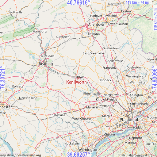
Kenilworth GPS coordinates[2]
40° 13' 53.364" North, 75° 38' 2.688" West
| Map corner | latitude | longitude |
|---|---|---|
| Upper-left | 40.76616°, | -76.33721° |
| Center: | 40.23149°, | -75.63408° |
| Lower-right: | 39.69257°, | -74.93096° |
| Map W x H: | 119.4×119.4 km | = 74.2×74.2mi |
| max Lat: | 71.29058° ⇑44.1% North |
| Kenilworth: | 40.23149° |
| min Lat: | ⇓55.9% South 19.06759° |
| min Long | Kenilworth | max Long |
| -171.73463° | -75.63408° | -66.98998° |
| W 85.2%⇐ | ⇒14.8% E |
Elevation
Elevation of Kenilworth is 57 m = 187 ft, and this is 237.8 m = 780 ft below average elevation for this country.
| Max E: |
3189 m = 10463 ft | 77.7% |
| Avg. | 294.8 m = 967 ft | |
| Kenilworth | 57 m = 187 ft | |
Min E: |
-60 m = -197 ft | 22.3% |
See also: United States elevation on elevation.city.
Geographical zone
Kenilworth is located in North temperate zone (between Tropic of Cancer and the Arctic Circle). Distance of this Northern Tropic circle is 1867.4 km =1160.3 mi to South.| Distance of | km | miles | from Kenilworth |
|---|---|---|---|
| North Pole | 5533.7 | 3438.5 | to North |
| Arctic Circle | 2927.9 | 1819.3 | to North |
| Tropic Cancer | 1867.4 | 1160.3 | to South |
| Equator | 4473.3 | 2779.6 | to South |


Nearby cities:
15 places around Kenilworth: (largest is in red/bold)
• Amity Gardens
9.8 km =6.1 mi,  298°
298°
• Boyertown
11.4 km =7.1 mi,  358°
358°
• Gilbertsville
10.1 km =6.3 mi,  11°
11°
• Halfway House
5.7 km =3.5 mi,  352°
352°
• Limerick
9.5 km =5.9 mi,  90°
90°
• New Berlinville
12.7 km =7.9 mi,  0°
0°
• Pottsgrove
4.2 km =2.6 mi,  26°
26°
• Pottstown
2 km =1.2 mi,  319°
319°
• Royersford
9.7 km =6 mi,  122°
122°
• Sanatoga
3.6 km =2.2 mi,  65°
65°
• Schwenksville
14.7 km =9.1 mi,  79°
79°
• South Pottstown
1.7 km =1.1 mi, 301°
• Spring City
9.5 km =5.9 mi,  129°
129°
• Stowe
4.4 km =2.7 mi, 302°
• Trappe
13.9 km =8.6 mi,  105°
105°
Sources, notices
• [Note1] Compared only with cities in United States existing in our database
• [Src1] Map data: © OpenStreetMap contributors (CC-BY-SA)
• [Src2] Other city data from geonames.org with taken over terms of usage.
• [Src3] Geographical zone / Annual Mean Temperature by Robert A. Rohde @ Wikipedia
