Mammoth geodata
Mammoth (Pennsylvania) is a populated place; located in United States in America/New_York (GMT-4) time zone. With population of 525 people, there are 20573 cities with bigger population in this country. Compared to other cities in United States, 55.5% of cities are located further ↓South; 74.9% of cities are located further ←West and 77.9% of cities have lower elevation than Mammoth. Note1
Administrative division(s):
- Level 1: Pennsylvania
- Level 2: Westmoreland County
- Level 3: Township of Mount Pleasant


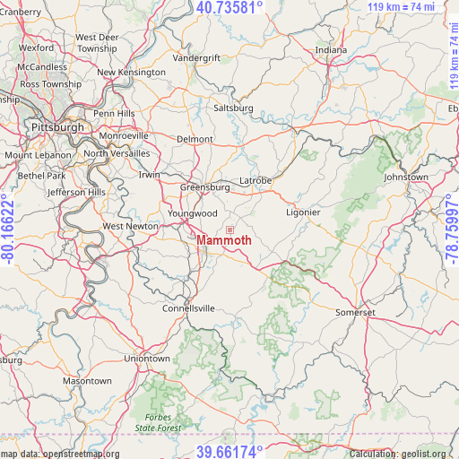
Mammoth GPS coordinates[2]
40° 12' 3.24" North, 79° 27' 47.124" West
| Map corner | latitude | longitude |
|---|---|---|
| Upper-left | 40.73581°, | -80.16622° |
| Center: | 40.2009°, | -79.46309° |
| Lower-right: | 39.66174°, | -78.75997° |
| Map W x H: | 119.4×119.4 km | = 74.2×74.2mi |
| max Lat: | 71.29058° ⇑44.5% North |
| Mammoth: | 40.2009° |
| min Lat: | ⇓55.5% South 19.06759° |
| min Long | Mammoth | max Long |
| -171.73463° | -79.46309° | -66.98998° |
| W 74.9%⇐ | ⇒25.1% E |
Elevation
Elevation of Mammoth is 335 m = 1099 ft, and this is 40.2 m = 132 ft above average elevation for this country.
| Max E: |
3189 m = 10463 ft | 22.1% |
| Mammoth | 335 m 1099 ft | |
| Avg. | 294.8 m = 967 ft | |
Min E: |
-60 m = -197 ft | 77.9% |
See also: United States elevation on elevation.city.
Geographical zone
Mammoth is located in North temperate zone (between Tropic of Cancer and the Arctic Circle). Distance of this Northern Tropic circle is 1864 km =1158.2 mi to South.| Distance of | km | miles | from Mammoth |
|---|---|---|---|
| North Pole | 5537.1 | 3440.6 | to North |
| Arctic Circle | 2931.3 | 1821.4 | to North |
| Tropic Cancer | 1864 | 1158.2 | to South |
| Equator | 4469.9 | 2777.5 | to South |


Nearby cities:
15 places around Mammoth: (largest is in red/bold)
• Bear Rocks
8.7 km =5.4 mi,  179°
179°
• Calumet
2.2 km =1.4 mi,  300°
300°
• Greensburg
12.9 km =8 mi,  330°
330°
• Hostetter
9.1 km =5.7 mi,  37°
37°
• Latrobe
15.1 km =9.4 mi,  27°
27°
• Lawson Heights
11.9 km =7.4 mi, 31°
• Loyalhanna
16 km =9.9 mi, 32°
• Mayfield
13.5 km =8.4 mi,  237°
237°
• Mount Pleasant
8.8 km =5.5 mi,  228°
228°
• New Stanton
12.6 km =7.8 mi,  279°
279°
• Norvelt
3 km =1.9 mi,  285°
285°
• Scottdale
15.4 km =9.6 mi,  223°
223°
• South Greensburg
11.1 km =6.9 mi,  321°
321°
• Southwest Greensburg
12.3 km =7.6 mi, 324°
• Youngwood
10.6 km =6.6 mi, 294°
Sources, notices
• [Note1] Compared only with cities in United States existing in our database
• [Src1] Map data: © OpenStreetMap contributors (CC-BY-SA)
• [Src2] Other city data from geonames.org with taken over terms of usage.
• [Src3] Geographical zone / Annual Mean Temperature by Robert A. Rohde @ Wikipedia
