Pittsburgh geodata
Pittsburgh (Pennsylvania) is a seat of a second-order administrative division; located in United States in America/New_York (GMT-4) time zone. With population of 304,391 people, there are 69 cities with bigger population in this country. Compared to other cities in United States, 58.4% of cities are located further ↓South; 73.3% of cities are located further ←West and 59.9% of cities have lower elevation than Pittsburgh. Note1
Administrative division(s):
- Level 1: Pennsylvania
- Level 2: Allegheny County
- Level 3: City of Pittsburgh


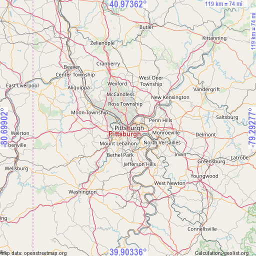
Pittsburgh GPS coordinates[2]
40° 26' 26.232" North, 79° 59' 45.204" West
| Map corner | latitude | longitude |
|---|---|---|
| Upper-left | 40.97362°, | -80.69902° |
| Center: | 40.44062°, | -79.99589° |
| Lower-right: | 39.90336°, | -79.29277° |
| Map W x H: | 119×119 km | = 73.9×73.9mi |
| max Lat: | 71.29058° ⇑41.6% North |
| Pittsburgh: | 40.44062° |
| min Lat: | ⇓58.4% South 19.06759° |
| min Long | Pittsburgh | max Long |
| -171.73463° | -79.99589° | -66.98998° |
| W 73.3%⇐ | ⇒26.7% E |
Elevation
Elevation of Pittsburgh is 239 m = 784 ft, and this is 55.8 m = 183 ft below average elevation for this country.
| Max E: |
3189 m = 10463 ft | 40.1% |
| Avg. | 294.8 m = 967 ft | |
| Pittsburgh | 239 m = 784 ft | |
Min E: |
-60 m = -197 ft | 59.9% |
See also: Pittsburgh elevation on elevation.city.
Geographical zone
Pittsburgh is located in North temperate zone (between Tropic of Cancer and the Arctic Circle). Distance of this Northern Tropic circle is 1890.7 km =1174.8 mi to South.| Distance of | km | miles | from Pittsburgh |
|---|---|---|---|
| North Pole | 5510.5 | 3424.1 | to North |
| Arctic Circle | 2904.6 | 1804.8 | to North |
| Tropic Cancer | 1890.7 | 1174.8 | to South |
| Equator | 4496.6 | 2794.1 | to South |


Nearby cities:
15 places around Pittsburgh: (largest is in red/bold)
• Bellevue
7.6 km =4.7 mi,  321°
321°
• Bloomfield
4.4 km =2.7 mi,  59°
59°
• Brentwood
8 km =5 mi,  167°
167°
• Carnegie
8.2 km =5.1 mi,  244°
244°
• Crafton
6 km =3.7 mi,  264°
264°
• Dormont
5.9 km =3.7 mi,  212°
212°
• Etna
8.1 km =5 mi,  29°
29°
• Green Tree
5.3 km =3.3 mi,  232°
232°
• Homestead
8.1 km =5 mi,  118°
118°
• Ingram
6.1 km =3.8 mi,  275°
275°
• Lawrenceville
4.2 km =2.6 mi,  44°
44°
• McKees Rocks
6.5 km =4 mi,  295°
295°
• Millvale
4.6 km =2.9 mi,  18°
18°
• Mount Oliver
3 km =1.9 mi, 166°
• Sharpsburg
8.4 km =5.2 mi, 44°
Sources, notices
• [Note1] Compared only with cities in United States existing in our database
• [Src1] Map data: © OpenStreetMap contributors (CC-BY-SA)
• [Src2] Other city data from geonames.org with taken over terms of usage.
• [Src3] Geographical zone / Annual Mean Temperature by Robert A. Rohde @ Wikipedia
