Reading geodata
Reading (Pennsylvania) is a seat of a second-order administrative division; located in United States in America/New_York (GMT-4) time zone. With population of 87,879 people, there are 426 cities with bigger population in this country. Compared to other cities in United States, 57.1% of cities are located further ↓South; 84.3% of cities are located further ←West and 73% of cities have higher elevation than Reading. Note1


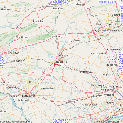
Reading GPS coordinates[2]
40° 20' 8.34" North, 75° 55' 36.732" West
| Map corner | latitude | longitude |
|---|---|---|
| Upper-left | 40.86949°, | -76.63° |
| Center: | 40.33565°, | -75.92687° |
| Lower-right: | 39.79756°, | -75.22375° |
| Map W x H: | 119.2×119.2 km | = 74.1×74.1mi |
| max Lat: | 71.29058° ⇑42.9% North |
| Reading: | 40.33565° |
| min Lat: | ⇓57.1% South 19.06759° |
| min Long | Reading | max Long |
| -171.73463° | -75.92687° | -66.98998° |
| W 84.3%⇐ | ⇒15.7% E |
Elevation
Elevation of Reading is 83 m = 272 ft, and this is 211.8 m = 695 ft below average elevation for this country.
| Max E: |
3189 m = 10463 ft | 73% |
| Avg. | 294.8 m = 967 ft | |
| Reading | 83 m = 272 ft | |
Min E: |
-60 m = -197 ft | 27% |
See also: Reading elevation on elevation.city.
Geographical zone
Reading is located in North temperate zone (between Tropic of Cancer and the Arctic Circle). Distance of this Northern Tropic circle is 1879 km =1167.6 mi to South.| Distance of | km | miles | from Reading |
|---|---|---|---|
| North Pole | 5522.2 | 3431.3 | to North |
| Arctic Circle | 2916.3 | 1812.1 | to North |
| Tropic Cancer | 1879 | 1167.6 | to South |
| Equator | 4484.9 | 2786.8 | to South |


Nearby cities:
15 places around Reading: (largest is in red/bold)
• Colony Park
4.9 km =3 mi,  284°
284°
• Greenfields
3.4 km =2.1 mi,  321°
321°
• Grill
4.3 km =2.7 mi,  195°
195°
• Hyde Park
4.6 km =2.9 mi,  1°
1°
• Kenhorst
3 km =1.9 mi, 200°
• Lincoln Park
5.5 km =3.4 mi,  244°
244°
• Mount Penn
3.2 km =2 mi,  105°
105°
• Pennside
4.1 km =2.5 mi,  87°
87°
• Reiffton
4.9 km =3 mi, 111°
• Saint Lawrence
4.8 km =3 mi,  101°
101°
• Shillington
4.5 km =2.8 mi,  226°
226°
• Stony Creek Mills
5 km =3.1 mi,  77°
77°
• West Reading
1.8 km =1.1 mi,  262°
262°
• Wyomissing
3.3 km =2.1 mi, 258°
• Wyomissing Hills
4.5 km =2.8 mi,  272°
272°
Sources, notices
• [Note1] Compared only with cities in United States existing in our database
• [Src1] Map data: © OpenStreetMap contributors (CC-BY-SA)
• [Src2] Other city data from geonames.org with taken over terms of usage.
• [Src3] Geographical zone / Annual Mean Temperature by Robert A. Rohde @ Wikipedia
