Sewickley Heights geodata
Sewickley Heights (Pennsylvania) is a populated place; located in United States in America/New_York (GMT-4) time zone. With population of 820 people, there are 17625 cities with bigger population in this country. Compared to other cities in United States, 59.5% of cities are located further ↓South; 72.4% of cities are located further ←West and 81.1% of cities have lower elevation than Sewickley Heights. Note1
Administrative division(s):
- Level 1: Pennsylvania
- Level 2: Allegheny County
- Level 3: Borough of Sewickley Heights


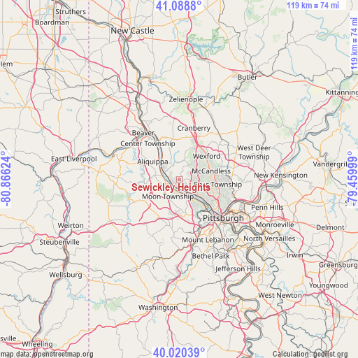
Sewickley Heights GPS coordinates[2]
40° 33' 24.228" North, 80° 9' 47.196" West
| Map corner | latitude | longitude |
|---|---|---|
| Upper-left | 41.0888°, | -80.86624° |
| Center: | 40.55673°, | -80.16311° |
| Lower-right: | 40.02039°, | -79.45999° |
| Map W x H: | 118.8×118.8 km | = 73.8×73.8mi |
| max Lat: | 71.29058° ⇑40.5% North |
| Sewickley Heights: | 40.55673° |
| min Lat: | ⇓59.5% South 19.06759° |
| min Long | Sewickley Heigh | max Long |
| -171.73463° | -80.16311° | -66.98998° |
| W 72.4%⇐ | ⇒27.6% E |
Elevation
Elevation of Sewickley Heights is 366 m = 1201 ft, and this is 71.2 m = 234 ft above average elevation for this country.
| Max E: |
3189 m = 10463 ft | 18.9% |
| Sewickley Heights | 366 m 1201 ft | |
| Avg. | 294.8 m = 967 ft | |
Min E: |
-60 m = -197 ft | 81.1% |
See also: United States elevation on elevation.city.
Geographical zone
Sewickley Heights is located in North temperate zone (between Tropic of Cancer and the Arctic Circle). Distance of this Northern Tropic circle is 1903.6 km =1182.8 mi to South.| Distance of | km | miles | from Sewickley Heights |
|---|---|---|---|
| North Pole | 5497.6 | 3416 | to North |
| Arctic Circle | 2891.7 | 1796.8 | to North |
| Tropic Cancer | 1903.6 | 1182.8 | to South |
| Equator | 4509.5 | 2802.1 | to South |


Nearby cities:
15 places around Sewickley Heights: (largest is in red/bold)
• Ambridge
6.4 km =4 mi,  304°
304°
• Avalon
10.2 km =6.3 mi,  127°
127°
• Baden
10.3 km =6.4 mi,  327°
327°
• Bell Acres
3.7 km =2.3 mi,  355°
355°
• Ben Avon
8.7 km =5.4 mi, 128°
• Carnot-Moon
6.2 km =3.9 mi,  227°
227°
• Coraopolis
4.3 km =2.7 mi,  184°
184°
• Economy
7.1 km =4.4 mi,  312°
312°
• Edgeworth
2.6 km =1.6 mi,  256°
256°
• Emsworth
7.8 km =4.8 mi, 131°
• Franklin Park
7 km =4.3 mi,  64°
64°
• Leetsdale
3.9 km =2.4 mi,  280°
280°
• Osborne
2.8 km =1.7 mi,  190°
190°
• Sewickley
2.9 km =1.8 mi,  218°
218°
• Sewickley Hills
3.6 km =2.2 mi,  38°
38°
Sources, notices
• [Note1] Compared only with cities in United States existing in our database
• [Src1] Map data: © OpenStreetMap contributors (CC-BY-SA)
• [Src2] Other city data from geonames.org with taken over terms of usage.
• [Src3] Geographical zone / Annual Mean Temperature by Robert A. Rohde @ Wikipedia
