Turtle Creek geodata
Turtle Creek (Pennsylvania) is a populated place; located in United States in America/New_York (GMT-4) time zone. With population of 5,272 people, there are 6940 cities with bigger population in this country. Compared to other cities in United States, 58% of cities are located further ↓South; 74.1% of cities are located further ←West and 57.2% of cities have lower elevation than Turtle Creek. Note1
Administrative division(s):
- Level 1: Pennsylvania
- Level 2: Allegheny County
- Level 3: Borough of Turtle Creek


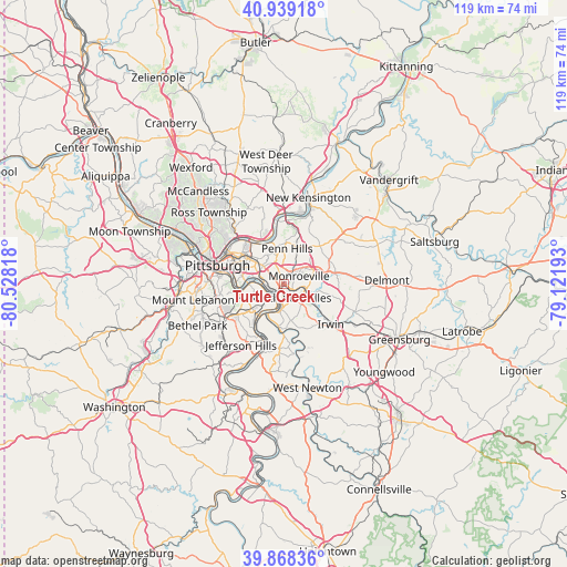
Turtle Creek GPS coordinates[2]
40° 24' 21.24" North, 79° 49' 30.18" West
| Map corner | latitude | longitude |
|---|---|---|
| Upper-left | 40.93918°, | -80.52818° |
| Center: | 40.4059°, | -79.82505° |
| Lower-right: | 39.86836°, | -79.12193° |
| Map W x H: | 119.1×119.1 km | = 74×74mi |
| max Lat: | 71.29058° ⇑42% North |
| Turtle Creek: | 40.4059° |
| min Lat: | ⇓58% South 19.06759° |
| min Long | Turtle Creek | max Long |
| -171.73463° | -79.82505° | -66.98998° |
| W 74.1%⇐ | ⇒25.9% E |
Elevation
Elevation of Turtle Creek is 227 m = 745 ft, and this is 67.8 m = 222 ft below average elevation for this country.
| Max E: |
3189 m = 10463 ft | 42.8% |
| Avg. | 294.8 m = 967 ft | |
| Turtle Creek | 227 m = 745 ft | |
Min E: |
-60 m = -197 ft | 57.2% |
See also: United States elevation on elevation.city.
Geographical zone
Turtle Creek is located in North temperate zone (between Tropic of Cancer and the Arctic Circle). Distance of this Northern Tropic circle is 1886.8 km =1172.4 mi to South.| Distance of | km | miles | from Turtle Creek |
|---|---|---|---|
| North Pole | 5514.3 | 3426.4 | to North |
| Arctic Circle | 2908.5 | 1807.3 | to North |
| Tropic Cancer | 1886.8 | 1172.4 | to South |
| Equator | 4492.7 | 2791.6 | to South |


Nearby cities:
15 places around Turtle Creek: (largest is in red/bold)
• Braddock
3.7 km =2.3 mi,  265°
265°
• Braddock Hills
3.6 km =2.2 mi,  290°
290°
• Chalfant
1.2 km =0.7 mi,  284°
284°
• Churchill
3.9 km =2.4 mi,  337°
337°
• Duquesne
4 km =2.5 mi,  227°
227°
• East McKeesport
3 km =1.9 mi,  148°
148°
• East Pittsburgh
1.6 km =1 mi, 225°
• Forest Hills
2.6 km =1.6 mi,  306°
306°
• Monroeville
3.6 km =2.2 mi,  61°
61°
• North Braddock
1.5 km =0.9 mi,  240°
240°
• North Versailles
3.2 km =2 mi,  155°
155°
• Pitcairn
4 km =2.5 mi,  94°
94°
• Rankin
4.6 km =2.9 mi, 279°
• Wall
3.6 km =2.2 mi,  112°
112°
• Wilmerding
2.1 km =1.3 mi,  142°
142°
Sources, notices
• [Note1] Compared only with cities in United States existing in our database
• [Src1] Map data: © OpenStreetMap contributors (CC-BY-SA)
• [Src2] Other city data from geonames.org with taken over terms of usage.
• [Src3] Geographical zone / Annual Mean Temperature by Robert A. Rohde @ Wikipedia
