Upper Exeter geodata
Upper Exeter (Pennsylvania) is a populated place; located in United States in America/New_York (GMT-4) time zone. With population of 707 people, there are 18602 cities with bigger population in this country. Compared to other cities in United States, 69.8% of cities are located further ↓South; 84.6% of cities are located further ←West and 54.2% of cities have higher elevation than Upper Exeter. Note1
Administrative division(s):
- Level 1: Pennsylvania
- Level 2: Luzerne County
- Level 3: Township of Exeter


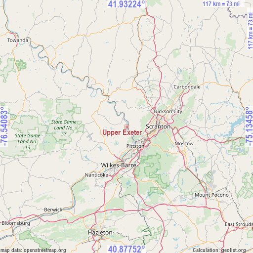
Upper Exeter GPS coordinates[2]
41° 24' 25.272" North, 75° 50' 15.72" West
| Map corner | latitude | longitude |
|---|---|---|
| Upper-left | 41.93224°, | -76.54083° |
| Center: | 41.40702°, | -75.8377° |
| Lower-right: | 40.87752°, | -75.13458° |
| Map W x H: | 117.3×117.3 km | = 72.9×72.9mi |
| max Lat: | 71.29058° ⇑30.2% North |
| Upper Exeter: | 41.40702° |
| min Lat: | ⇓69.8% South 19.06759° |
| min Long | Upper Exeter | max Long |
| -171.73463° | -75.8377° | -66.98998° |
| W 84.6%⇐ | ⇒15.4% E |
Elevation
Elevation of Upper Exeter is 183 m = 600 ft, and this is 111.8 m = 367 ft below average elevation for this country.
| Max E: |
3189 m = 10463 ft | 54.2% |
| Avg. | 294.8 m = 967 ft | |
| Upper Exeter | 183 m = 600 ft | |
Min E: |
-60 m = -197 ft | 45.8% |
See also: United States elevation on elevation.city.
Geographical zone
Upper Exeter is located in North temperate zone (between Tropic of Cancer and the Arctic Circle). Distance of this Northern Tropic circle is 1998.1 km =1241.6 mi to South.| Distance of | km | miles | from Upper Exeter |
|---|---|---|---|
| North Pole | 5403 | 3357.3 | to North |
| Arctic Circle | 2797.1 | 1738 | to North |
| Tropic Cancer | 1998.1 | 1241.6 | to South |
| Equator | 4604 | 2860.8 | to South |


Nearby cities:
15 places around Upper Exeter: (largest is in red/bold)
• Avoca
11.3 km =7 mi,  131°
131°
• Browntown
11.6 km =7.2 mi,  158°
158°
• Dupont
11.9 km =7.4 mi,  139°
139°
• Duryea
10.8 km =6.7 mi, 130°
• Exeter
9.7 km =6 mi,  170°
170°
• Hughestown
10.4 km =6.5 mi,  148°
148°
• Inkerman
12.2 km =7.6 mi, 170°
• Lake Winola
11.2 km =7 mi,  353°
353°
• Moosic
10.2 km =6.3 mi, 125°
• Old Forge
9.5 km =5.9 mi,  114°
114°
• Pittston
9.9 km =6.2 mi, 155°
• Taylor
11 km =6.8 mi,  97°
97°
• West Pittston
9.6 km =6 mi, 157°
• West Wyoming
9.7 km =6 mi,  184°
184°
• Wyoming
10.6 km =6.6 mi, 179°
Sources, notices
• [Note1] Compared only with cities in United States existing in our database
• [Src1] Map data: © OpenStreetMap contributors (CC-BY-SA)
• [Src2] Other city data from geonames.org with taken over terms of usage.
• [Src3] Geographical zone / Annual Mean Temperature by Robert A. Rohde @ Wikipedia
