Wernersville geodata
Wernersville (Pennsylvania) is a populated place; located in United States in America/New_York (GMT-4) time zone. With population of 2,540 people, there are 10518 cities with bigger population in this country. Compared to other cities in United States, 57% of cities are located further ↓South; 83.8% of cities are located further ←West and 68% of cities have higher elevation than Wernersville. Note1
Administrative division(s):
- Level 1: Pennsylvania
- Level 2: Berks County
- Level 3: Borough of Wernersville


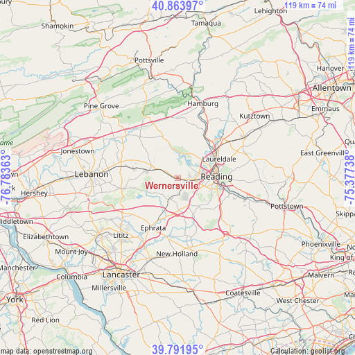
Wernersville GPS coordinates[2]
40° 19' 48.324" North, 76° 4' 49.8" West
| Map corner | latitude | longitude |
|---|---|---|
| Upper-left | 40.86397°, | -76.78363° |
| Center: | 40.33009°, | -76.0805° |
| Lower-right: | 39.79195°, | -75.37738° |
| Map W x H: | 119.2×119.2 km | = 74.1×74.1mi |
| max Lat: | 71.29058° ⇑43% North |
| Wernersville: | 40.33009° |
| min Lat: | ⇓57% South 19.06759° |
| min Long | Wernersville | max Long |
| -171.73463° | -76.0805° | -66.98998° |
| W 83.8%⇐ | ⇒16.2% E |
Elevation
Elevation of Wernersville is 112 m = 367 ft, and this is 182.8 m = 600 ft below average elevation for this country.
| Max E: |
3189 m = 10463 ft | 68% |
| Avg. | 294.8 m = 967 ft | |
| Wernersville | 112 m = 367 ft | |
Min E: |
-60 m = -197 ft | 32% |
See also: United States elevation on elevation.city.
Geographical zone
Wernersville is located in North temperate zone (between Tropic of Cancer and the Arctic Circle). Distance of this Northern Tropic circle is 1878.4 km =1167.2 mi to South.| Distance of | km | miles | from Wernersville |
|---|---|---|---|
| North Pole | 5522.8 | 3431.7 | to North |
| Arctic Circle | 2916.9 | 1812.5 | to North |
| Tropic Cancer | 1878.4 | 1167.2 | to South |
| Equator | 4484.3 | 2786.4 | to South |


Nearby cities:
15 places around Wernersville: (largest is in red/bold)
• Colony Park
8.5 km =5.3 mi,  77°
77°
• Gouglersville
8.1 km =5 mi,  140°
140°
• Lincoln Park
8.2 km =5.1 mi,  101°
101°
• Mohnton
9.5 km =5.9 mi,  121°
121°
• Montrose
8.3 km =5.2 mi,  108°
108°
• Montrose Manor
8.2 km =5.1 mi, 109°
• Reinholds
7.6 km =4.7 mi,  202°
202°
• Robesonia
5.2 km =3.2 mi,  297°
297°
• Sinking Spring
5.9 km =3.7 mi,  93°
93°
• Spring Ridge
8.1 km =5 mi,  71°
71°
• Springmont
6.9 km =4.3 mi, 93°
• West Lawn
7.3 km =4.5 mi, 90°
• West Wyomissing
7.6 km =4.7 mi, 94°
• Whitfield
6.3 km =3.9 mi, 84°
• Wyomissing Hills
8.6 km =5.3 mi, 84°
Sources, notices
• [Note1] Compared only with cities in United States existing in our database
• [Src1] Map data: © OpenStreetMap contributors (CC-BY-SA)
• [Src2] Other city data from geonames.org with taken over terms of usage.
• [Src3] Geographical zone / Annual Mean Temperature by Robert A. Rohde @ Wikipedia
