Humboldt geodata
Humboldt (South Dakota) is a populated place; located in United States in America/Chicago (GMT-5) time zone. With population of 583 people, there are 19876 cities with bigger population in this country. Compared to other cities in United States, 86.9% of cities are located further ↓South; 75.9% of cities are located further →East and 88.3% of cities have lower elevation than Humboldt. Note1
Administrative division(s):
- Level 1: South Dakota
- Level 2: Minnehaha County
- Level 3: Town of Humboldt


Humboldt GPS coordinates[2]
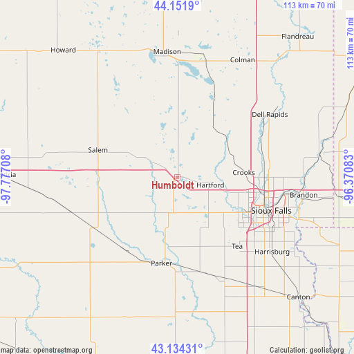
43° 38' 42.936" North, 97° 4' 26.22" West
| Map corner | latitude | longitude |
|---|---|---|
| Upper-left | 44.1519°, | -97.77708° |
| Center: | 43.64526°, | -97.07395° |
| Lower-right: | 43.13431°, | -96.37083° |
| Map W x H: | 113.1×113.1 km | = 70.3×70.3mi |
| max Lat: | 71.29058° ⇑13.1% North |
| Humboldt: | 43.64526° |
| min Lat: | ⇓86.9% South 19.06759° |
| min Long | Humboldt | max Long |
| -171.73463° | -97.07395° | -66.98998° |
| W 24.1%⇐ | ⇒75.9% E |
Elevation
Elevation of Humboldt is 519 m = 1703 ft, and this is 224.2 m = 736 ft above average elevation for this country.
| Max E: |
3189 m = 10463 ft | 11.7% |
| Humboldt | 519 m 1703 ft | |
| Avg. | 294.8 m = 967 ft | |
Min E: |
-60 m = -197 ft | 88.3% |
See also: United States elevation on elevation.city.
Geographical zone
Humboldt is located in North temperate zone (between Tropic of Cancer and the Arctic Circle). Distance of this Northern Tropic circle is 2247 km =1396.2 mi to South.| Distance of | km | miles | from Humboldt |
|---|---|---|---|
| North Pole | 5154.2 | 3202.7 | to North |
| Arctic Circle | 2548.3 | 1583.4 | to North |
| Tropic Cancer | 2247 | 1396.2 | to South |
| Equator | 4852.9 | 3015.5 | to South |


Nearby cities:
15 places around Humboldt: (largest is in red/bold)
• Baltic
29.8 km =18.5 mi,  64°
64°
• Canistota
18.2 km =11.3 mi,  253°
253°
• Colton
19.6 km =12.2 mi,  36°
36°
• Crooks
21.3 km =13.2 mi,  84°
84°
• Dell Rapids
35.7 km =22.2 mi, 55°
• Harrisburg
38.6 km =24 mi,  128°
128°
• Hartford
10.9 km =6.8 mi,  103°
103°
• Lennox
35.5 km =22.1 mi,  155°
155°
• Marion
28.9 km =18 mi,  211°
211°
• Meadow View Addition
29.3 km =18.2 mi, 95°
• Parker
28 km =17.4 mi,  190°
190°
• Salem
26.8 km =16.7 mi,  289°
289°
• Shindler
39.1 km =24.3 mi,  118°
118°
• Sioux Falls
31.9 km =19.8 mi,  109°
109°
• Tea
29.3 km =18.2 mi,  139°
139°
Sources, notices
• [Note1] Compared only with cities in United States existing in our database
• [Src1] Map data: © OpenStreetMap contributors (CC-BY-SA)
• [Src2] Other city data from geonames.org with taken over terms of usage.
• [Src3] Geographical zone / Annual Mean Temperature by Robert A. Rohde @ Wikipedia
