Bennington geodata
Bennington (Vermont) is a populated place; located in United States in America/New_York (GMT-4) time zone. With population of 9,074 people, there are 4771 cities with bigger population in this country. Compared to other cities in United States, 82.4% of cities are located further ↓South; 93.5% of cities are located further ←West and 52.5% of cities have lower elevation than Bennington. Note1


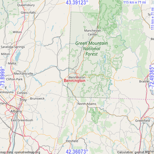
Bennington GPS coordinates[2]
42° 52' 41.268" North, 73° 11' 48.372" West
| Map corner | latitude | longitude |
|---|---|---|
| Upper-left | 43.39123°, | -73.8999° |
| Center: | 42.87813°, | -73.19677° |
| Lower-right: | 42.36073°, | -72.49365° |
| Map W x H: | 114.6×114.6 km | = 71.2×71.2mi |
| max Lat: | 71.29058° ⇑17.6% North |
| Bennington: | 42.87813° |
| min Lat: | ⇓82.4% South 19.06759° |
| min Long | Bennington | max Long |
| -171.73463° | -73.19677° | -66.98998° |
| W 93.5%⇐ | ⇒6.5% E |
Elevation
Elevation of Bennington is 208 m = 682 ft, and this is 86.8 m = 285 ft below average elevation for this country.
| Max E: |
3189 m = 10463 ft | 47.5% |
| Avg. | 294.8 m = 967 ft | |
| Bennington | 208 m = 682 ft | |
Min E: |
-60 m = -197 ft | 52.5% |
See also: United States elevation on elevation.city.
Geographical zone
Bennington is located in North temperate zone (between Tropic of Cancer and the Arctic Circle). Distance of this Northern Tropic circle is 2161.7 km =1343.2 mi to South.| Distance of | km | miles | from Bennington |
|---|---|---|---|
| North Pole | 5239.5 | 3255.7 | to North |
| Arctic Circle | 2633.6 | 1636.4 | to North |
| Tropic Cancer | 2161.7 | 1343.2 | to South |
| Equator | 4767.6 | 2962.4 | to South |


Nearby cities:
15 places around Bennington: (largest is in red/bold)
• Adams
29 km =18 mi,  167°
167°
• Arlington
22.1 km =13.7 mi,  9°
9°
• Cambridge
22.4 km =13.9 mi,  318°
318°
• Dover
32.8 km =20.4 mi,  77°
77°
• Florida
28 km =17.4 mi,  147°
147°
• Greenwich
34.1 km =21.2 mi,  313°
313°
• Hoosick Falls
12.9 km =8 mi,  281°
281°
• Manchester
33.3 km =20.7 mi,  17°
17°
• North Adams
21 km =13 mi,  159°
159°
• North Bennington
6.9 km =4.3 mi,  327°
327°
• Pownal
12.9 km =8 mi,  194°
194°
• Salem
34.4 km =21.4 mi,  341°
341°
• Schaghticoke
31.8 km =19.8 mi,  274°
274°
• South Shaftsbury
7.7 km =4.8 mi,  351°
351°
• Williamstown
18.5 km =11.5 mi,  181°
181°
Sources, notices
• [Note1] Compared only with cities in United States existing in our database
• [Src1] Map data: © OpenStreetMap contributors (CC-BY-SA)
• [Src2] Other city data from geonames.org with taken over terms of usage.
• [Src3] Geographical zone / Annual Mean Temperature by Robert A. Rohde @ Wikipedia
