Rutland geodata
Rutland (Vermont) is a seat of a second-order administrative division; located in United States in America/New_York (GMT-4) time zone. With population of 15,824 people, there are 3095 cities with bigger population in this country. Compared to other cities in United States, 86.8% of cities are located further ↓South; 94% of cities are located further ←West and 50.5% of cities have lower elevation than Rutland. Note1


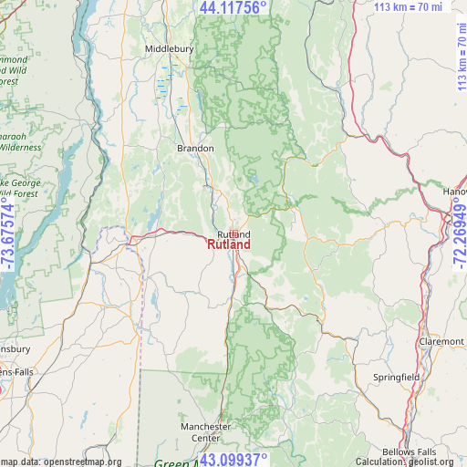
Rutland GPS coordinates[2]
43° 36' 38.232" North, 72° 58' 21.396" West
| Map corner | latitude | longitude |
|---|---|---|
| Upper-left | 44.11756°, | -73.67574° |
| Center: | 43.61062°, | -72.97261° |
| Lower-right: | 43.09937°, | -72.26949° |
| Map W x H: | 113.2×113.2 km | = 70.3×70.3mi |
| max Lat: | 71.29058° ⇑13.2% North |
| Rutland: | 43.61062° |
| min Lat: | ⇓86.8% South 19.06759° |
| min Long | Rutland | max Long |
| -171.73463° | -72.97261° | -66.98998° |
| W 94%⇐ | ⇒6% E |
Elevation
Elevation of Rutland is 200 m = 656 ft, and this is 94.8 m = 311 ft below average elevation for this country.
| Max E: |
3189 m = 10463 ft | 49.5% |
| Avg. | 294.8 m = 967 ft | |
| Rutland | 200 m = 656 ft | |
Min E: |
-60 m = -197 ft | 50.5% |
See also: United States elevation on elevation.city.
Geographical zone
Rutland is located in North temperate zone (between Tropic of Cancer and the Arctic Circle). Distance of this Northern Tropic circle is 2243.1 km =1393.8 mi to South.| Distance of | km | miles | from Rutland |
|---|---|---|---|
| North Pole | 5158 | 3205 | to North |
| Arctic Circle | 2552.1 | 1585.8 | to North |
| Tropic Cancer | 2243.1 | 1393.8 | to South |
| Equator | 4849 | 3013 | to South |


Nearby cities:
15 places around Rutland: (largest is in red/bold)
• Brandon
22.8 km =14.2 mi,  336°
336°
• Castleton
16.7 km =10.4 mi,  270°
270°
• Chittenden
11 km =6.8 mi,  10°
10°
• Clarendon
10.5 km =6.5 mi,  178°
178°
• Danby
29.5 km =18.3 mi, 183°
• Fair Haven
23.7 km =14.7 mi, 265°
• Hampton
24.4 km =15.2 mi,  247°
247°
• Leicester
30.5 km =19 mi, 339°
• Mendon
5.8 km =3.6 mi,  38°
38°
• Mount Holly
21.3 km =13.2 mi,  145°
145°
• Pittsfield
22.1 km =13.7 mi, 35°
• Pittsford
11.6 km =7.2 mi, 337°
• Poultney
23.7 km =14.7 mi,  243°
243°
• Wallingford
15.4 km =9.6 mi, 181°
• West Rutland
6.2 km =3.9 mi, 251°
Sources, notices
• [Note1] Compared only with cities in United States existing in our database
• [Src1] Map data: © OpenStreetMap contributors (CC-BY-SA)
• [Src2] Other city data from geonames.org with taken over terms of usage.
• [Src3] Geographical zone / Annual Mean Temperature by Robert A. Rohde @ Wikipedia
