Juneau geodata
Juneau (Wisconsin) is a seat of a second-order administrative division; located in United States in America/Chicago (GMT-5) time zone. With population of 2,692 people, there are 10198 cities with bigger population in this country. Compared to other cities in United States, 85.9% of cities are located further ↓South; 55.4% of cities are located further →East and 69.5% of cities have lower elevation than Juneau. Note1


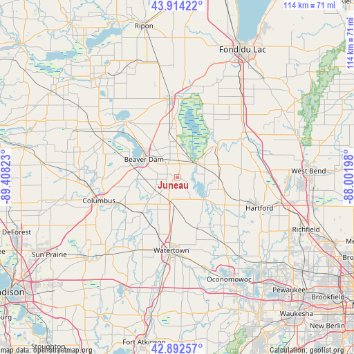
Juneau GPS coordinates[2]
43° 24' 19.98" North, 88° 42' 18.36" West
| Map corner | latitude | longitude |
|---|---|---|
| Upper-left | 43.91422°, | -89.40823° |
| Center: | 43.40555°, | -88.7051° |
| Lower-right: | 42.89257°, | -88.00198° |
| Map W x H: | 113.6×113.6 km | = 70.6×70.6mi |
| max Lat: | 71.29058° ⇑14.1% North |
| Juneau: | 43.40555° |
| min Lat: | ⇓85.9% South 19.06759° |
| min Long | Juneau | max Long |
| -171.73463° | -88.7051° | -66.98998° |
| W 44.6%⇐ | ⇒55.4% E |
Elevation
Elevation of Juneau is 283 m = 928 ft, and this is 11.8 m = 39 ft below average elevation for this country.
| Max E: |
3189 m = 10463 ft | 30.5% |
| Avg. | 294.8 m = 967 ft | |
| Juneau | 283 m = 928 ft | |
Min E: |
-60 m = -197 ft | 69.5% |
See also: United States elevation on elevation.city.
Geographical zone
Juneau is located in North temperate zone (between Tropic of Cancer and the Arctic Circle). Distance of this Northern Tropic circle is 2220.3 km =1379.6 mi to South.| Distance of | km | miles | from Juneau |
|---|---|---|---|
| North Pole | 5180.8 | 3219.2 | to North |
| Arctic Circle | 2574.9 | 1600 | to North |
| Tropic Cancer | 2220.3 | 1379.6 | to South |
| Equator | 4826.2 | 2998.9 | to South |


Nearby cities:
15 places around Juneau: (largest is in red/bold)
• Addison
26.8 km =16.7 mi,  85°
85°
• Beaver Dam
12.2 km =7.6 mi,  298°
298°
• Columbus
26.2 km =16.3 mi,  253°
253°
• Fall River
27.6 km =17.1 mi,  265°
265°
• Fox Lake
24.1 km =15 mi,  317°
317°
• Hartford
28.1 km =17.5 mi,  110°
110°
• Horicon
7.8 km =4.8 mi,  49°
49°
• Hustisford
10.7 km =6.6 mi,  128°
128°
• Iron Ridge
14 km =8.7 mi, 92°
• Mayville
16.3 km =10.1 mi, 52°
• Neosho
18.5 km =11.5 mi, 125°
• Reeseville
15.9 km =9.9 mi,  225°
225°
• Theresa
24 km =14.9 mi,  58°
58°
• Watertown
23.5 km =14.6 mi,  184°
184°
• Waupun
25.4 km =15.8 mi,  355°
355°
Sources, notices
• [Note1] Compared only with cities in United States existing in our database
• [Src1] Map data: © OpenStreetMap contributors (CC-BY-SA)
• [Src2] Other city data from geonames.org with taken over terms of usage.
• [Src3] Geographical zone / Annual Mean Temperature by Robert A. Rohde @ Wikipedia
