Poynette geodata
Poynette (Wisconsin) is a populated place; located in United States in America/Chicago (GMT-5) time zone. With population of 2,493 people, there are 10630 cities with bigger population in this country. Compared to other cities in United States, 85.8% of cities are located further ↓South; 57.3% of cities are located further →East and 64.1% of cities have lower elevation than Poynette. Note1
Administrative division(s):
- Level 1: Wisconsin
- Level 2: Columbia County
- Level 3: Village of Poynette


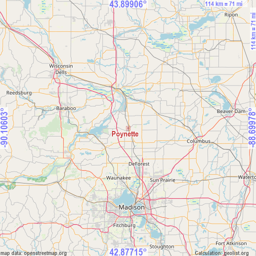
Poynette GPS coordinates[2]
43° 23' 24.936" North, 89° 24' 10.44" West
| Map corner | latitude | longitude |
|---|---|---|
| Upper-left | 43.89906°, | -90.10603° |
| Center: | 43.39026°, | -89.4029° |
| Lower-right: | 42.87715°, | -88.69978° |
| Map W x H: | 113.6×113.6 km | = 70.6×70.6mi |
| max Lat: | 71.29058° ⇑14.2% North |
| Poynette: | 43.39026° |
| min Lat: | ⇓85.8% South 19.06759° |
| min Long | Poynette | max Long |
| -171.73463° | -89.4029° | -66.98998° |
| W 42.7%⇐ | ⇒57.3% E |
Elevation
Elevation of Poynette is 258 m = 846 ft, and this is 36.8 m = 121 ft below average elevation for this country.
| Max E: |
3189 m = 10463 ft | 35.9% |
| Avg. | 294.8 m = 967 ft | |
| Poynette | 258 m = 846 ft | |
Min E: |
-60 m = -197 ft | 64.1% |
See also: United States elevation on elevation.city.
Geographical zone
Poynette is located in North temperate zone (between Tropic of Cancer and the Arctic Circle). Distance of this Northern Tropic circle is 2218.6 km =1378.6 mi to South.| Distance of | km | miles | from Poynette |
|---|---|---|---|
| North Pole | 5182.5 | 3220.3 | to North |
| Arctic Circle | 2576.6 | 1601 | to North |
| Tropic Cancer | 2218.6 | 1378.6 | to South |
| Equator | 4824.5 | 2997.8 | to South |


Nearby cities:
15 places around Poynette: (largest is in red/bold)
• Arlington
6.1 km =3.8 mi,  162°
162°
• Dane
17.5 km =10.9 mi,  207°
207°
• De Forest
16.6 km =10.3 mi, 163°
• Fall River
28.9 km =18 mi,  91°
91°
• Lake Wisconsin
14.1 km =8.8 mi,  262°
262°
• Lodi
13.1 km =8.1 mi,  229°
229°
• Pardeeville
18.4 km =11.4 mi,  26°
26°
• Portage
17.2 km =10.7 mi,  343°
343°
• Prairie du Sac
28.4 km =17.6 mi,  246°
246°
• Rio
14.6 km =9.1 mi,  64°
64°
• Roxbury
27 km =16.8 mi, 234°
• Sun Prairie
27.6 km =17.1 mi,  146°
146°
• Waunakee
22.5 km =14 mi,  190°
190°
• Windsor
19.8 km =12.3 mi,  165°
165°
• Wyocena
14 km =8.7 mi, 33°
Sources, notices
• [Note1] Compared only with cities in United States existing in our database
• [Src1] Map data: © OpenStreetMap contributors (CC-BY-SA)
• [Src2] Other city data from geonames.org with taken over terms of usage.
• [Src3] Geographical zone / Annual Mean Temperature by Robert A. Rohde @ Wikipedia
