Whitewater geodata
Whitewater (Wisconsin) is a populated place; located in United States in America/Chicago (GMT-5) time zone. With population of 14,692 people, there are 3299 cities with bigger population in this country. Compared to other cities in United States, 82.1% of cities are located further ↓South; 55.4% of cities are located further →East and 62.8% of cities have lower elevation than Whitewater. Note1


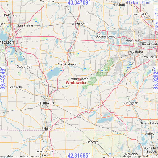
Whitewater GPS coordinates[2]
42° 50' 1.032" North, 88° 43' 56.388" West
| Map corner | latitude | longitude |
|---|---|---|
| Upper-left | 43.34709°, | -89.43546° |
| Center: | 42.83362°, | -88.73233° |
| Lower-right: | 42.31585°, | -88.02921° |
| Map W x H: | 114.7×114.7 km | = 71.3×71.3mi |
| max Lat: | 71.29058° ⇑17.9% North |
| Whitewater: | 42.83362° |
| min Lat: | ⇓82.1% South 19.06759° |
| min Long | Whitewater | max Long |
| -171.73463° | -88.73233° | -66.98998° |
| W 44.6%⇐ | ⇒55.4% E |
Elevation
Elevation of Whitewater is 252 m = 827 ft, and this is 42.8 m = 140 ft below average elevation for this country.
| Max E: |
3189 m = 10463 ft | 37.2% |
| Avg. | 294.8 m = 967 ft | |
| Whitewater | 252 m = 827 ft | |
Min E: |
-60 m = -197 ft | 62.8% |
See also: United States elevation on elevation.city.
Geographical zone
Whitewater is located in North temperate zone (between Tropic of Cancer and the Arctic Circle). Distance of this Northern Tropic circle is 2156.7 km =1340.1 mi to South.| Distance of | km | miles | from Whitewater |
|---|---|---|---|
| North Pole | 5244.4 | 3258.7 | to North |
| Arctic Circle | 2638.5 | 1639.5 | to North |
| Tropic Cancer | 2156.7 | 1340.1 | to South |
| Equator | 4762.7 | 2959.4 | to South |


Nearby cities:
15 places around Whitewater: (largest is in red/bold)
• Darien
25.9 km =16.1 mi,  175°
175°
• Delavan
23.4 km =14.5 mi,  162°
162°
• Eagle
21.6 km =13.4 mi,  76°
76°
• East Troy
27.2 km =16.9 mi,  101°
101°
• Edgerton
27.3 km =17 mi,  270°
270°
• Elkhorn
23.6 km =14.7 mi,  139°
139°
• Fort Atkinson
13.6 km =8.5 mi,  321°
321°
• Jefferson
20.1 km =12.5 mi,  342°
342°
• Johnson Creek
27.2 km =16.9 mi,  352°
352°
• Lake Koshkonong
17.4 km =10.8 mi,  299°
299°
• Milton
18.4 km =11.4 mi,  249°
249°
• Palmyra
12.9 km =8 mi,  67°
67°
• Richmond
13.3 km =8.3 mi,  185°
185°
• Rome
18.3 km =11.4 mi,  26°
26°
• Sullivan
23.1 km =14.4 mi, 30°
Sources, notices
• [Note1] Compared only with cities in United States existing in our database
• [Src1] Map data: © OpenStreetMap contributors (CC-BY-SA)
• [Src2] Other city data from geonames.org with taken over terms of usage.
• [Src3] Geographical zone / Annual Mean Temperature by Robert A. Rohde @ Wikipedia
