Pinetop-Lakeside geodata
Pinetop-Lakeside (Arizona) is a populated place; located in United States in America/Phoenix (GMT-7) time zone. With population of 4,345 people, there are 7818 cities with bigger population in this country. Compared to other cities in United States, 79.3% of cities are located further ↑North; 85.7% of cities are located further →East and 99.3% of cities have lower elevation than Pinetop-Lakeside. Note1


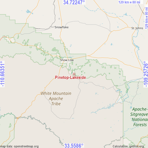
Pinetop-Lakeside GPS coordinates[2]
34° 8' 33.144" North, 109° 57' 37.368" West
| Map corner | latitude | longitude |
|---|---|---|
| Upper-left | 34.72247°, | -110.66351° |
| Center: | 34.14254°, | -109.96038° |
| Lower-right: | 33.5586°, | -109.25726° |
| Map W x H: | 129.4×129.4 km | = 80.4×80.4mi |
| max Lat: | 71.29058° ⇑79.3% North |
| Pinetop-Lakeside: | 34.14254° |
| min Lat: | ⇓20.7% South 19.06759° |
| min Long | Pinetop-Lakesid | max Long |
| -171.73463° | -109.96038° | -66.98998° |
| W 14.3%⇐ | ⇒85.7% E |
Elevation
Elevation of Pinetop-Lakeside is 2079 m = 6821 ft, and this is 1784.2 m = 5854 ft above average elevation for this country.
| Max E: |
3189 m = 10463 ft | 0.7% |
| Pinetop-Lakeside | 2079 m 6821 ft | |
| Avg. | 294.8 m = 967 ft | |
Min E: |
-60 m = -197 ft | 99.3% |
See also: United States elevation on elevation.city.
Geographical zone
Pinetop-Lakeside is located in North temperate zone (between Tropic of Cancer and the Arctic Circle). Distance of this Northern Tropic circle is 1190.4 km =739.7 mi to South.| Distance of | km | miles | from Pinetop-Lakeside |
|---|---|---|---|
| North Pole | 6210.8 | 3859.2 | to North |
| Arctic Circle | 3604.9 | 2240 | to North |
| Tropic Cancer | 1190.4 | 739.7 | to South |
| Equator | 3796.3 | 2358.9 | to South |


Nearby cities:
15 places around Pinetop-Lakeside: (largest is in red/bold)
• Canyon Day
40.2 km =25 mi,  188°
188°
• Cibecue
49.5 km =30.8 mi,  257°
257°
• East Fork
38.4 km =23.9 mi,  175°
175°
• Hondah
5.9 km =3.7 mi,  155°
155°
• Lake of the Woods
3.6 km =2.2 mi,  311°
311°
• Linden
24 km =14.9 mi, 311°
• McNary
12.2 km =7.6 mi,  128°
128°
• North Fork
15.7 km =9.8 mi, 181°
• Rainbow City
30 km =18.6 mi, 182°
• Sevenmile
39.7 km =24.7 mi, 179°
• Show Low
14 km =8.7 mi,  332°
332°
• Snowflake
42.6 km =26.5 mi,  345°
345°
• Taylor
37.8 km =23.5 mi,  341°
341°
• White Mountain Lake
23.2 km =14.4 mi, 351°
• Whiteriver
34 km =21.1 mi, 180°
Sources, notices
• [Note1] Compared only with cities in United States existing in our database
• [Src1] Map data: © OpenStreetMap contributors (CC-BY-SA)
• [Src2] Other city data from geonames.org with taken over terms of usage.
• [Src3] Geographical zone / Annual Mean Temperature by Robert A. Rohde @ Wikipedia
