Whetstone geodata
Whetstone (Arizona) is a populated place; located in United States in America/Phoenix (GMT-7) time zone. With population of 2,617 people, there are 10357 cities with bigger population in this country. Compared to other cities in United States, 88.7% of cities are located further ↑North; 85.9% of cities are located further →East and 94.8% of cities have lower elevation than Whetstone. Note1


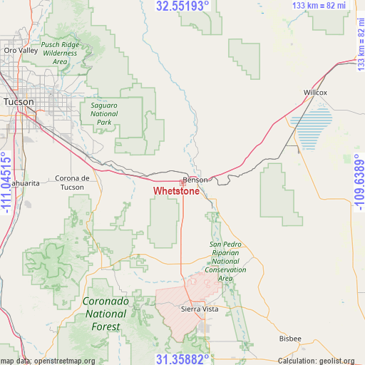
Whetstone GPS coordinates[2]
31° 57' 26.316" North, 110° 20' 31.272" West
| Map corner | latitude | longitude |
|---|---|---|
| Upper-left | 32.55193°, | -111.04515° |
| Center: | 31.95731°, | -110.34202° |
| Lower-right: | 31.35882°, | -109.6389° |
| Map W x H: | 132.7×132.7 km | = 82.5×82.5mi |
| max Lat: | 71.29058° ⇑88.7% North |
| Whetstone: | 31.95731° |
| min Lat: | ⇓11.3% South 19.06759° |
| min Long | Whetstone | max Long |
| -171.73463° | -110.34202° | -66.98998° |
| W 14.1%⇐ | ⇒85.9% E |
Elevation
Elevation of Whetstone is 1237 m = 4058 ft, and this is 942.2 m = 3091 ft above average elevation for this country.
| Max E: |
3189 m = 10463 ft | 5.2% |
| Whetstone | 1237 m 4058 ft | |
| Avg. | 294.8 m = 967 ft | |
Min E: |
-60 m = -197 ft | 94.8% |
See also: United States elevation on elevation.city.
Geographical zone
Whetstone is located in North temperate zone (between Tropic of Cancer and the Arctic Circle). Distance of this Northern Tropic circle is 947.4 km =588.7 mi to South.| Distance of | km | miles | from Whetstone |
|---|---|---|---|
| North Pole | 6453.7 | 4010.1 | to North |
| Arctic Circle | 3847.9 | 2391 | to North |
| Tropic Cancer | 947.4 | 588.7 | to South |
| Equator | 3553.3 | 2207.9 | to South |


Nearby cities:
15 places around Whetstone: (largest is in red/bold)
• Benson
4.6 km =2.9 mi,  75°
75°
• Corona de Tucson
40.9 km =25.4 mi,  271°
271°
• East Sahuarita
55.3 km =34.4 mi, 268°
• Huachuca City
36.6 km =22.7 mi,  178°
178°
• Littletown
53.6 km =33.3 mi,  291°
291°
• Mescal
9.5 km =5.9 mi, 292°
• Pimaco Two
10.5 km =6.5 mi, 265°
• Saint David
13.4 km =8.3 mi,  116°
116°
• Sierra Vista
44.9 km =27.9 mi, 175°
• Sierra Vista Southeast
57.2 km =35.5 mi,  168°
168°
• Sonoita
42.9 km =26.7 mi,  223°
223°
• Tanque Verde
49.6 km =30.8 mi,  311°
311°
• Tombstone
37.6 km =23.4 mi,  136°
136°
• Vail
36.3 km =22.6 mi, 286°
• Whetstone
28.5 km =17.7 mi, 179°
Sources, notices
• [Note1] Compared only with cities in United States existing in our database
• [Src1] Map data: © OpenStreetMap contributors (CC-BY-SA)
• [Src2] Other city data from geonames.org with taken over terms of usage.
• [Src3] Geographical zone / Annual Mean Temperature by Robert A. Rohde @ Wikipedia
