Avila Beach geodata
Avila Beach (California) is a populated place; located in United States in America/Los_Angeles (GMT-7) time zone. With population of 1,627 people, there are 13186 cities with bigger population in this country. Compared to other cities in United States, 74.4% of cities are located further ↑North; 93.5% of cities are located further →East and 86.2% of cities have higher elevation than Avila Beach. Note1


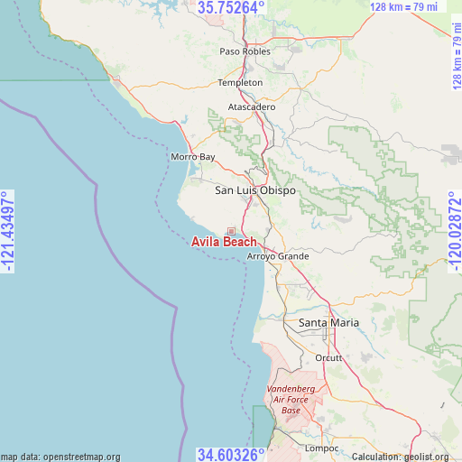
Avila Beach GPS coordinates[2]
35° 10' 47.928" North, 120° 43' 54.624" West
| Map corner | latitude | longitude |
|---|---|---|
| Upper-left | 35.75264°, | -121.43497° |
| Center: | 35.17998°, | -120.73184° |
| Lower-right: | 34.60326°, | -120.02872° |
| Map W x H: | 127.8×127.8 km | = 79.4×79.4mi |
| max Lat: | 71.29058° ⇑74.4% North |
| Avila Beach: | 35.17998° |
| min Lat: | ⇓25.6% South 19.06759° |
| min Long | Avila Beach | max Long |
| -171.73463° | -120.73184° | -66.98998° |
| W 6.5%⇐ | ⇒93.5% E |
Elevation
Elevation of Avila Beach is 25 m = 82 ft, and this is 269.8 m = 885 ft below average elevation for this country.
| Max E: |
3189 m = 10463 ft | 86.2% |
| Avg. | 294.8 m = 967 ft | |
| Avila Beach | 25 m = 82 ft | |
Min E: |
-60 m = -197 ft | 13.8% |
See also: United States elevation on elevation.city.
Geographical zone
Avila Beach is located in North temperate zone (between Tropic of Cancer and the Arctic Circle). Distance of this Northern Tropic circle is 1305.7 km =811.3 mi to South.| Distance of | km | miles | from Avila Beach |
|---|---|---|---|
| North Pole | 6095.4 | 3787.5 | to North |
| Arctic Circle | 3489.5 | 2168.3 | to North |
| Tropic Cancer | 1305.7 | 811.3 | to South |
| Equator | 3911.6 | 2430.6 | to South |


Nearby cities:
15 places around Avila Beach: (largest is in red/bold)
• Arroyo Grande
14.5 km =9 mi,  118°
118°
• Blacklake
22.8 km =14.2 mi,  129°
129°
• Callender
18.7 km =11.6 mi,  138°
138°
• Cayucos
32.6 km =20.3 mi,  333°
333°
• Grover Beach
12 km =7.5 mi, 122°
• Guadalupe
27.4 km =17 mi,  147°
147°
• Los Berros
20.6 km =12.8 mi, 123°
• Los Osos
17.2 km =10.7 mi, 327°
• Morro Bay
23.3 km =14.5 mi, 332°
• Nipomo
27.8 km =17.3 mi, 123°
• Oceano
14.1 km =8.8 mi, 129°
• Pismo Beach
9.2 km =5.7 mi, 116°
• San Luis Obispo
13.2 km =8.2 mi,  29°
29°
• Santa Margarita
25.9 km =16.1 mi, 25°
• Woodlands
23.4 km =14.5 mi, 135°
Sources, notices
• [Note1] Compared only with cities in United States existing in our database
• [Src1] Map data: © OpenStreetMap contributors (CC-BY-SA)
• [Src2] Other city data from geonames.org with taken over terms of usage.
• [Src3] Geographical zone / Annual Mean Temperature by Robert A. Rohde @ Wikipedia
