Chinatown geodata
Chinatown (California) is a section of populated place; located in United States in America/Los_Angeles (GMT-7) time zone. With population of 100,574 people, there are 346 cities with bigger population in this country. Compared to other cities in United States, 62.7% of cities are located further ↑North; 96.4% of cities are located further →East and 83.6% of cities have higher elevation than Chinatown. Note1


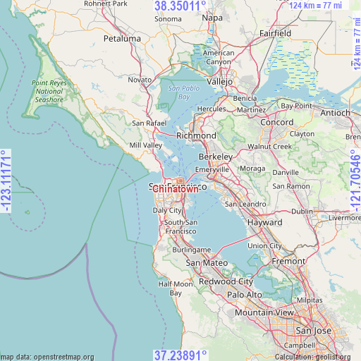
Chinatown GPS coordinates[2]
37° 47' 47.76" North, 122° 24' 30.888" West
| Map corner | latitude | longitude |
|---|---|---|
| Upper-left | 38.35011°, | -123.11171° |
| Center: | 37.7966°, | -122.40858° |
| Lower-right: | 37.23891°, | -121.70546° |
| Map W x H: | 123.6×123.6 km | = 76.8×76.8mi |
| max Lat: | 71.29058° ⇑62.7% North |
| Chinatown: | 37.7966° |
| min Lat: | ⇓37.3% South 19.06759° |
| min Long | Chinatown | max Long |
| -171.73463° | -122.40858° | -66.98998° |
| W 3.6%⇐ | ⇒96.4% E |
Elevation
Elevation of Chinatown is 33 m = 108 ft, and this is 261.8 m = 859 ft below average elevation for this country.
| Max E: |
3189 m = 10463 ft | 83.6% |
| Avg. | 294.8 m = 967 ft | |
| Chinatown | 33 m = 108 ft | |
Min E: |
-60 m = -197 ft | 16.4% |
See also: Chinatown elevation on elevation.city.
Geographical zone
Chinatown is located in North temperate zone (between Tropic of Cancer and the Arctic Circle). Distance of this Northern Tropic circle is 1596.7 km =992.1 mi to South.| Distance of | km | miles | from Chinatown |
|---|---|---|---|
| North Pole | 5804.5 | 3606.7 | to North |
| Arctic Circle | 3198.6 | 1987.5 | to North |
| Tropic Cancer | 1596.7 | 992.1 | to South |
| Equator | 4202.6 | 2611.4 | to South |


Nearby cities:
15 places around Chinatown: (largest is in red/bold)
• Albany
14 km =8.7 mi,  44°
44°
• Belvedere
9.8 km =6.1 mi,  329°
329°
• Brisbane
12.9 km =8 mi,  176°
176°
• Broadmoor
13.9 km =8.6 mi,  208°
208°
• Colma
14 km =8.7 mi,  198°
198°
• Daly City
11.1 km =6.9 mi, 204°
• Emeryville
11.5 km =7.1 mi,  70°
70°
• Marin City
11.9 km =7.4 mi,  312°
312°
• Mission District
4.2 km =2.6 mi,  192°
192°
• Noe Valley
5.6 km =3.5 mi, 203°
• Oakland
12.1 km =7.5 mi,  85°
85°
• San Francisco
2.6 km =1.6 mi, 201°
• Sausalito
9.7 km =6 mi,  315°
315°
• Tiburon
9.5 km =5.9 mi, 333°
• Visitacion Valley
8.8 km =5.5 mi, 177°
Sources, notices
• [Note1] Compared only with cities in United States existing in our database
• [Src1] Map data: © OpenStreetMap contributors (CC-BY-SA)
• [Src2] Other city data from geonames.org with taken over terms of usage.
• [Src3] Geographical zone / Annual Mean Temperature by Robert A. Rohde @ Wikipedia
