Coto De Caza geodata
Coto De Caza (California) is a populated place; located in United States in America/Los_Angeles (GMT-7) time zone. With population of 14,866 people, there are 3268 cities with bigger population in this country. Compared to other cities in United States, 82.6% of cities are located further ↑North; 90.4% of cities are located further →East and 54.7% of cities have lower elevation than Coto De Caza. Note1


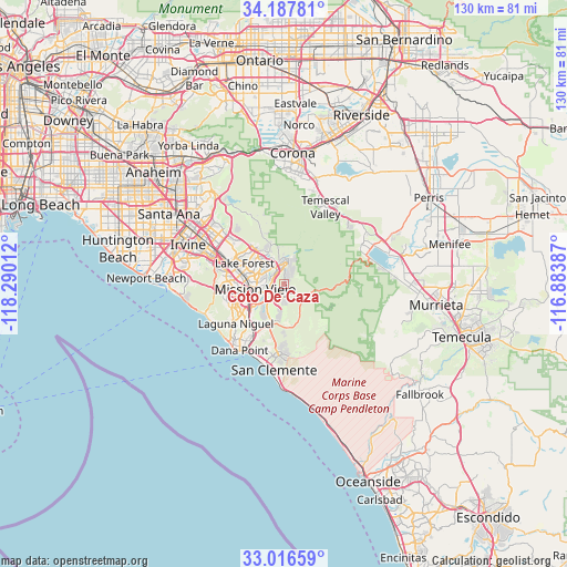
Coto De Caza GPS coordinates[2]
33° 36' 15.084" North, 117° 35' 13.164" West
| Map corner | latitude | longitude |
|---|---|---|
| Upper-left | 34.18781°, | -118.29012° |
| Center: | 33.60419°, | -117.58699° |
| Lower-right: | 33.01659°, | -116.88387° |
| Map W x H: | 130.2×130.2 km | = 80.9×80.9mi |
| max Lat: | 71.29058° ⇑82.6% North |
| Coto De Caza: | 33.60419° |
| min Lat: | ⇓17.4% South 19.06759° |
| min Long | Coto De Caza | max Long |
| -171.73463° | -117.58699° | -66.98998° |
| W 9.6%⇐ | ⇒90.4% E |
Elevation
Elevation of Coto De Caza is 217 m = 712 ft, and this is 77.8 m = 255 ft below average elevation for this country.
| Max E: |
3189 m = 10463 ft | 45.3% |
| Avg. | 294.8 m = 967 ft | |
| Coto De Caza | 217 m = 712 ft | |
Min E: |
-60 m = -197 ft | 54.7% |
See also: United States elevation on elevation.city.
Geographical zone
Coto De Caza is located in North temperate zone (between Tropic of Cancer and the Arctic Circle). Distance of this Northern Tropic circle is 1130.5 km =702.5 mi to South.| Distance of | km | miles | from Coto De Caza |
|---|---|---|---|
| North Pole | 6270.6 | 3896.4 | to North |
| Arctic Circle | 3664.7 | 2277.1 | to North |
| Tropic Cancer | 1130.5 | 702.5 | to South |
| Equator | 3736.4 | 2321.7 | to South |


Nearby cities:
15 places around Coto De Caza: (largest is in red/bold)
• Aliso Viejo
13.7 km =8.5 mi,  251°
251°
• Dana Point
18.4 km =11.4 mi,  214°
214°
• Foothill Ranch
11.4 km =7.1 mi,  323°
323°
• Ladera Ranch
5.8 km =3.6 mi,  230°
230°
• Laguna Beach
19.4 km =12.1 mi, 249°
• Laguna Hills
11.7 km =7.3 mi,  274°
274°
• Laguna Niguel
14.4 km =8.9 mi, 230°
• Laguna Woods
12.8 km =8 mi, 273°
• Lake Forest
10.6 km =6.6 mi,  296°
296°
• Las Flores
4.1 km =2.5 mi,  244°
244°
• Mission Viejo
7.9 km =4.9 mi, 266°
• Portola Hills
9.3 km =5.8 mi,  333°
333°
• Rancho Santa Margarita
4.3 km =2.7 mi,  339°
339°
• San Juan Capistrano
13.4 km =8.3 mi, 211°
• Trabuco Canyon
6.5 km =4 mi,  357°
357°
Sources, notices
• [Note1] Compared only with cities in United States existing in our database
• [Src1] Map data: © OpenStreetMap contributors (CC-BY-SA)
• [Src2] Other city data from geonames.org with taken over terms of usage.
• [Src3] Geographical zone / Annual Mean Temperature by Robert A. Rohde @ Wikipedia
