Danville geodata
Danville (California) is a populated place; located in United States in America/Los_Angeles (GMT-7) time zone. With population of 44,400 people, there are 1073 cities with bigger population in this country. Compared to other cities in United States, 62.6% of cities are located further ↑North; 95.1% of cities are located further →East and 68.3% of cities have higher elevation than Danville. Note1


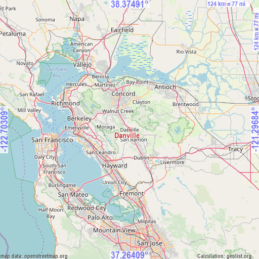
Danville GPS coordinates[2]
37° 49' 17.724" North, 121° 59' 59.856" West
| Map corner | latitude | longitude |
|---|---|---|
| Upper-left | 38.37491°, | -122.70309° |
| Center: | 37.82159°, | -121.99996° |
| Lower-right: | 37.26409°, | -121.29684° |
| Map W x H: | 123.5×123.5 km | = 76.7×76.7mi |
| max Lat: | 71.29058° ⇑62.6% North |
| Danville: | 37.82159° |
| min Lat: | ⇓37.4% South 19.06759° |
| min Long | Danville | max Long |
| -171.73463° | -121.99996° | -66.98998° |
| W 4.9%⇐ | ⇒95.1% E |
Elevation
Elevation of Danville is 111 m = 364 ft, and this is 183.8 m = 603 ft below average elevation for this country.
| Max E: |
3189 m = 10463 ft | 68.3% |
| Avg. | 294.8 m = 967 ft | |
| Danville | 111 m = 364 ft | |
Min E: |
-60 m = -197 ft | 31.7% |
See also: Danville elevation on elevation.city.
Geographical zone
Danville is located in North temperate zone (between Tropic of Cancer and the Arctic Circle). Distance of this Northern Tropic circle is 1599.4 km =993.8 mi to South.| Distance of | km | miles | from Danville |
|---|---|---|---|
| North Pole | 5801.7 | 3605 | to North |
| Arctic Circle | 3195.8 | 1985.8 | to North |
| Tropic Cancer | 1599.4 | 993.8 | to South |
| Equator | 4205.4 | 2613.1 | to South |


Nearby cities:
15 places around Danville: (largest is in red/bold)
• Acalanes Ridge
11.5 km =7.1 mi,  323°
323°
• Alamo
4.3 km =2.7 mi, 318°
• Blackhawk
8.1 km =5 mi,  90°
90°
• Clayton
14.4 km =8.9 mi,  22°
22°
• Contra Costa Centre
12.8 km =8 mi,  336°
336°
• Diablo
4 km =2.5 mi,  68°
68°
• Dublin
14.4 km =8.9 mi,  156°
156°
• Lafayette
12.6 km =7.8 mi,  304°
304°
• Moraga
11.5 km =7.1 mi,  277°
277°
• North Gate
9.4 km =5.8 mi,  0°
0°
• Pleasant Hill
15 km =9.3 mi, 339°
• San Ramon
5 km =3.1 mi, 157°
• Saranap
9.7 km =6 mi, 316°
• Waldon
12.6 km =7.8 mi, 337°
• Walnut Creek
11 km =6.8 mi,  328°
328°
Sources, notices
• [Note1] Compared only with cities in United States existing in our database
• [Src1] Map data: © OpenStreetMap contributors (CC-BY-SA)
• [Src2] Other city data from geonames.org with taken over terms of usage.
• [Src3] Geographical zone / Annual Mean Temperature by Robert A. Rohde @ Wikipedia
