Las Flores geodata
Las Flores (California) is a section of populated place; located in United States in America/Los_Angeles (GMT-7) time zone. With population of 6,037 people, there are 6375 cities with bigger population in this country. Compared to other cities in United States, 80% of cities are located further ↑North; 91.7% of cities are located further →East and 86.6% of cities have higher elevation than Las Flores. Note1


Las Flores GPS coordinates[2]
34° 2' 14.028" North, 118° 38' 9.312" West
| Map corner | latitude | longitude |
|---|---|---|
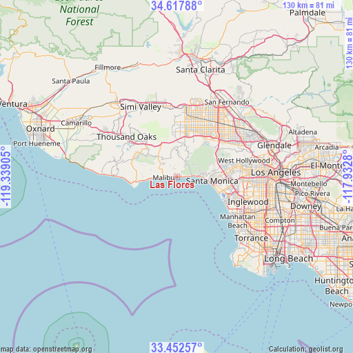
| Upper-left | 34.61788°, | -119.33905° |
| Center: | 34.03723°, | -118.63592° |
| Lower-right: | 33.45257°, | -117.9328° |
| Map W x H: | 129.6×129.6 km | = 80.5×80.5mi |
| max Lat: | 71.29058° ⇑80% North |
| Las Flores: | 34.03723° |
| min Lat: | ⇓20% South 19.06759° |
| min Long | Las Flores | max Long |
| -171.73463° | -118.63592° | -66.98998° |
| W 8.3%⇐ | ⇒91.7% E |
Elevation
Elevation of Las Flores is 24 m = 79 ft, and this is 270.8 m = 888 ft below average elevation for this country.
| Max E: |
3189 m = 10463 ft | 86.6% |
| Avg. | 294.8 m = 967 ft | |
| Las Flores | 24 m = 79 ft | |
Min E: |
-60 m = -197 ft | 13.4% |
See also: United States elevation on elevation.city.
Geographical zone
Las Flores is located in North temperate zone (between Tropic of Cancer and the Arctic Circle). Distance of this Northern Tropic circle is 1178.7 km =732.4 mi to South.| Distance of | km | miles | from Las Flores |
|---|---|---|---|
| North Pole | 6222.5 | 3866.5 | to North |
| Arctic Circle | 3616.6 | 2247.3 | to North |
| Tropic Cancer | 1178.7 | 732.4 | to South |
| Equator | 3784.6 | 2351.6 | to South |


Nearby cities:
15 places around Las Flores: (largest is in red/bold)
• Agoura
15.1 km =9.4 mi,  321°
321°
• Agoura Hills
16.9 km =10.5 mi,  310°
310°
• Calabasas
13.4 km =8.3 mi,  359°
359°
• Canoga Park
18.6 km =11.6 mi,  10°
10°
• Encino
18.4 km =11.4 mi,  42°
42°
• Hidden Hills
13.8 km =8.6 mi,  353°
353°
• Malibu
13.4 km =8.3 mi,  264°
264°
• Marina del Rey
18.1 km =11.2 mi,  110°
110°
• Oak Park
19.6 km =12.2 mi, 323°
• Santa Monica
13.5 km =8.4 mi,  98°
98°
• Topanga
7 km =4.3 mi,  26°
26°
• Venice
17 km =10.6 mi, 107°
• West Hills
17.8 km =11.1 mi, 357°
• Westwood
19 km =11.8 mi,  83°
83°
• Woodland Hills
14.8 km =9.2 mi, 10°
Sources, notices
• [Note1] Compared only with cities in United States existing in our database
• [Src1] Map data: © OpenStreetMap contributors (CC-BY-SA)
• [Src2] Other city data from geonames.org with taken over terms of usage.
• [Src3] Geographical zone / Annual Mean Temperature by Robert A. Rohde @ Wikipedia
