Questa geodata
Questa (New Mexico) is a populated place; located in United States in America/Denver (GMT-6) time zone. With population of 1,753 people, there are 12730 cities with bigger population in this country. Compared to other cities in United States, 67.3% of cities are located further ↑North; 83.7% of cities are located further →East and 99.7% of cities have lower elevation than Questa. Note1


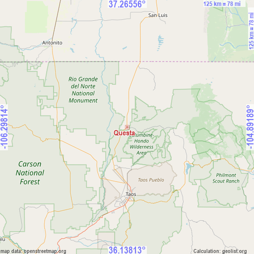
Questa GPS coordinates[2]
36° 42' 14.076" North, 105° 35' 42.036" West
| Map corner | latitude | longitude |
|---|---|---|
| Upper-left | 37.26556°, | -106.29814° |
| Center: | 36.70391°, | -105.59501° |
| Lower-right: | 36.13813°, | -104.89189° |
| Map W x H: | 125.4×125.4 km | = 77.9×77.9mi |
| max Lat: | 71.29058° ⇑67.3% North |
| Questa: | 36.70391° |
| min Lat: | ⇓32.7% South 19.06759° |
| min Long | Questa | max Long |
| -171.73463° | -105.59501° | -66.98998° |
| W 16.3%⇐ | ⇒83.7% E |
Elevation
Elevation of Questa is 2274 m = 7461 ft, and this is 1979.2 m = 6493 ft above average elevation for this country.
| Max E: |
3189 m = 10463 ft | 0.3% |
| Questa | 2274 m 7461 ft | |
| Avg. | 294.8 m = 967 ft | |
Min E: |
-60 m = -197 ft | 99.7% |
See also: United States elevation on elevation.city.
Geographical zone
Questa is located in North temperate zone (between Tropic of Cancer and the Arctic Circle). Distance of this Northern Tropic circle is 1475.2 km =916.6 mi to South.| Distance of | km | miles | from Questa |
|---|---|---|---|
| North Pole | 5926 | 3682.2 | to North |
| Arctic Circle | 3320.1 | 2063 | to North |
| Tropic Cancer | 1475.2 | 916.6 | to South |
| Equator | 4081.1 | 2535.9 | to South |


Nearby cities:
15 places around Questa: (largest is in red/bold)
• Angel Fire
44.3 km =27.5 mi,  141°
141°
• Antonito
55.6 km =34.5 mi,  318°
318°
• Arroyo Seco
20.9 km =13 mi,  173°
173°
• Cimarron
64.3 km =40 mi,  109°
109°
• Conejos
57 km =35.4 mi, 318°
• Dixon
62 km =38.5 mi,  205°
205°
• El Rito
66.5 km =41.3 mi,  232°
232°
• Manassa
60.5 km =37.6 mi,  329°
329°
• Peñasco
60 km =37.3 mi,  187°
187°
• Ranchos de Taos
38.4 km =23.9 mi,  181°
181°
• San Luis
57.3 km =35.6 mi,  15°
15°
• Sanford
67.5 km =41.9 mi,  335°
335°
• Talpa
40.3 km =25 mi, 180°
• Taos
33 km =20.5 mi, 176°
• Taos Pueblo
29.8 km =18.5 mi, 171°
Sources, notices
• [Note1] Compared only with cities in United States existing in our database
• [Src1] Map data: © OpenStreetMap contributors (CC-BY-SA)
• [Src2] Other city data from geonames.org with taken over terms of usage.
• [Src3] Geographical zone / Annual Mean Temperature by Robert A. Rohde @ Wikipedia
