Valencia geodata
Valencia (New Mexico) is a populated place; located in United States in America/Denver (GMT-6) time zone. With population of 2,192 people, there are 11366 cities with bigger population in this country. Compared to other cities in United States, 76.4% of cities are located further ↑North; 84.5% of cities are located further →East and 96.5% of cities have lower elevation than Valencia. Note1


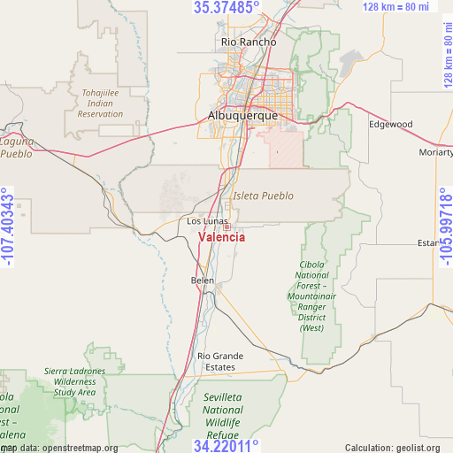
Valencia GPS coordinates[2]
34° 47' 58.2" North, 106° 42' 1.08" West
| Map corner | latitude | longitude |
|---|---|---|
| Upper-left | 35.37485°, | -107.40343° |
| Center: | 34.7995°, | -106.7003° |
| Lower-right: | 34.22011°, | -105.99718° |
| Map W x H: | 128.4×128.4 km | = 79.8×79.8mi |
| max Lat: | 71.29058° ⇑76.4% North |
| Valencia: | 34.7995° |
| min Lat: | ⇓23.6% South 19.06759° |
| min Long | Valencia | max Long |
| -171.73463° | -106.7003° | -66.98998° |
| W 15.5%⇐ | ⇒84.5% E |
Elevation
Elevation of Valencia is 1477 m = 4846 ft, and this is 1182.2 m = 3879 ft above average elevation for this country.
| Max E: |
3189 m = 10463 ft | 3.5% |
| Valencia | 1477 m 4846 ft | |
| Avg. | 294.8 m = 967 ft | |
Min E: |
-60 m = -197 ft | 96.5% |
See also: United States elevation on elevation.city.
Geographical zone
Valencia is located in North temperate zone (between Tropic of Cancer and the Arctic Circle). Distance of this Northern Tropic circle is 1263.4 km =785 mi to South.| Distance of | km | miles | from Valencia |
|---|---|---|---|
| North Pole | 6137.7 | 3813.8 | to North |
| Arctic Circle | 3531.8 | 2194.6 | to North |
| Tropic Cancer | 1263.4 | 785 | to South |
| Equator | 3869.3 | 2404.3 | to South |


Nearby cities:
15 places around Valencia: (largest is in red/bold)
• Adelino
9.7 km =6 mi,  196°
196°
• Belen
16.7 km =10.4 mi, 204°
• Bosque Farms
6.2 km =3.9 mi,  355°
355°
• El Cerro
8.1 km =5 mi,  186°
186°
• El Cerro Mission
6.6 km =4.1 mi,  129°
129°
• Jarales
21.5 km =13.4 mi, 195°
• Las Maravillas
7.4 km =4.6 mi,  156°
156°
• Los Chavez
9.7 km =6 mi,  212°
212°
• Los Lunas
3.1 km =1.9 mi,  283°
283°
• Meadow Lake
14.3 km =8.9 mi,  89°
89°
• Monterey Park
7.1 km =4.4 mi, 129°
• Peralta
4.3 km =2.7 mi,  12°
12°
• Pueblitos
20.9 km =13 mi, 199°
• Rio Communities
17 km =10.6 mi, 190°
• Tome
7 km =4.3 mi, 201°
Sources, notices
• [Note1] Compared only with cities in United States existing in our database
• [Src1] Map data: © OpenStreetMap contributors (CC-BY-SA)
• [Src2] Other city data from geonames.org with taken over terms of usage.
• [Src3] Geographical zone / Annual Mean Temperature by Robert A. Rohde @ Wikipedia
