Yerington geodata
Yerington (Nevada) is a seat of a second-order administrative division; located in United States in America/Los_Angeles (GMT-7) time zone. With population of 3,064 people, there are 9537 cities with bigger population in this country. Compared to other cities in United States, 55% of cities are located further ↑North; 92% of cities are located further →East and 95.6% of cities have lower elevation than Yerington. Note1


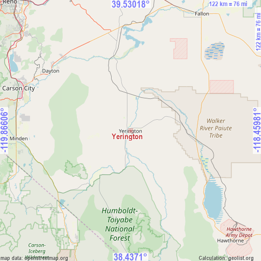
Yerington GPS coordinates[2]
38° 59' 8.7" North, 119° 9' 46.548" West
| Map corner | latitude | longitude |
|---|---|---|
| Upper-left | 39.53018°, | -119.86606° |
| Center: | 38.98575°, | -119.16293° |
| Lower-right: | 38.4371°, | -118.45981° |
| Map W x H: | 121.5×121.5 km | = 75.5×75.5mi |
| max Lat: | 71.29058° ⇑55% North |
| Yerington: | 38.98575° |
| min Lat: | ⇓45% South 19.06759° |
| min Long | Yerington | max Long |
| -171.73463° | -119.16293° | -66.98998° |
| W 8%⇐ | ⇒92% E |
Elevation
Elevation of Yerington is 1342 m = 4403 ft, and this is 1047.2 m = 3436 ft above average elevation for this country.
| Max E: |
3189 m = 10463 ft | 4.4% |
| Yerington | 1342 m 4403 ft | |
| Avg. | 294.8 m = 967 ft | |
Min E: |
-60 m = -197 ft | 95.6% |
See also: United States elevation on elevation.city.
Geographical zone
Yerington is located in North temperate zone (between Tropic of Cancer and the Arctic Circle). Distance of this Northern Tropic circle is 1728.9 km =1074.3 mi to South.| Distance of | km | miles | from Yerington |
|---|---|---|---|
| North Pole | 5672.3 | 3524.6 | to North |
| Arctic Circle | 3066.4 | 1905.4 | to North |
| Tropic Cancer | 1728.9 | 1074.3 | to South |
| Equator | 4334.8 | 2693.5 | to South |


Nearby cities:
15 places around Yerington: (largest is in red/bold)
• Carter Springs
43.6 km =27.1 mi,  251°
251°
• Dayton
46.5 km =28.9 mi,  306°
306°
• East Valley
46.6 km =29 mi,  264°
264°
• Fish Springs
42.4 km =26.3 mi,  265°
265°
• Gardnerville
51 km =31.7 mi, 264°
• Gardnerville Ranchos
51.2 km =31.8 mi, 257°
• Indian Hills
54.8 km =34.1 mi,  281°
281°
• Johnson Lane
48.8 km =30.3 mi, 278°
• Minden
52.2 km =32.4 mi, 266°
• Schurz
30.6 km =19 mi,  97°
97°
• Silver Springs
48.1 km =29.9 mi,  353°
353°
• Smith
25 km =15.5 mi,  214°
214°
• Smith Valley
27.4 km =17 mi,  215°
215°
• Stagecoach
46.8 km =29.1 mi,  337°
337°
• Topaz Ranch Estates
40.4 km =25.1 mi,  226°
226°
Sources, notices
• [Note1] Compared only with cities in United States existing in our database
• [Src1] Map data: © OpenStreetMap contributors (CC-BY-SA)
• [Src2] Other city data from geonames.org with taken over terms of usage.
• [Src3] Geographical zone / Annual Mean Temperature by Robert A. Rohde @ Wikipedia
