Perryton geodata
Perryton (Texas) is a seat of a second-order administrative division; located in United States in America/Chicago (GMT-5) time zone. With population of 9,252 people, there are 4707 cities with bigger population in this country. Compared to other cities in United States, 68.5% of cities are located further ↑North; 81.2% of cities are located further →East and 92.8% of cities have lower elevation than Perryton. Note1


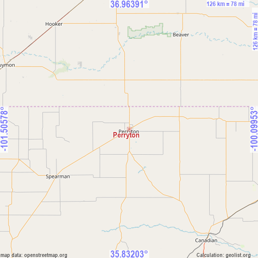
Perryton GPS coordinates[2]
36° 24' 0.108" North, 100° 48' 9.54" West
| Map corner | latitude | longitude |
|---|---|---|
| Upper-left | 36.96391°, | -101.50578° |
| Center: | 36.40003°, | -100.80265° |
| Lower-right: | 35.83203°, | -100.09953° |
| Map W x H: | 125.9×125.9 km | = 78.2×78.2mi |
| max Lat: | 71.29058° ⇑68.5% North |
| Perryton: | 36.40003° |
| min Lat: | ⇓31.5% South 19.06759° |
| min Long | Perryton | max Long |
| -171.73463° | -100.80265° | -66.98998° |
| W 18.8%⇐ | ⇒81.2% E |
Elevation
Elevation of Perryton is 903 m = 2963 ft, and this is 608.2 m = 1995 ft above average elevation for this country.
| Max E: |
3189 m = 10463 ft | 7.2% |
| Perryton | 903 m 2963 ft | |
| Avg. | 294.8 m = 967 ft | |
Min E: |
-60 m = -197 ft | 92.8% |
See also: United States elevation on elevation.city.
Geographical zone
Perryton is located in North temperate zone (between Tropic of Cancer and the Arctic Circle). Distance of this Northern Tropic circle is 1441.4 km =895.6 mi to South.| Distance of | km | miles | from Perryton |
|---|---|---|---|
| North Pole | 5959.8 | 3703.2 | to North |
| Arctic Circle | 3353.9 | 2084 | to North |
| Tropic Cancer | 1441.4 | 895.6 | to South |
| Equator | 4047.3 | 2514.9 | to South |


Nearby cities:
15 places around Perryton: (largest is in red/bold)
• Beaver
52.7 km =32.7 mi,  28°
28°
• Booker
24.5 km =15.2 mi,  75°
75°
• Canadian
66 km =41 mi,  145°
145°
• Forgan
61.1 km =38 mi,  22°
22°
• Goodwell
77.6 km =48.2 mi,  286°
286°
• Gruver
56.1 km =34.9 mi,  254°
254°
• Guymon
68.3 km =42.4 mi,  297°
297°
• Hooker
62.9 km =39.1 mi,  324°
324°
• Laverne
88.2 km =54.8 mi,  67°
67°
• Liberal
72.3 km =44.9 mi,  351°
351°
• Miami
80.2 km =49.8 mi,  169°
169°
• Shattuck
83.5 km =51.9 mi,  99°
99°
• Spearman
41.5 km =25.8 mi,  237°
237°
• Stinnett
85.8 km =53.3 mi,  222°
222°
• Tyrone
65.9 km =40.9 mi,  339°
339°
Sources, notices
• [Note1] Compared only with cities in United States existing in our database
• [Src1] Map data: © OpenStreetMap contributors (CC-BY-SA)
• [Src2] Other city data from geonames.org with taken over terms of usage.
• [Src3] Geographical zone / Annual Mean Temperature by Robert A. Rohde @ Wikipedia
