Pojoaque geodata
Pojoaque (New Mexico) is a populated place; located in United States in America/Denver (GMT-6) time zone. With population of 1,907 people, there are 12206 cities with bigger population in this country. Compared to other cities in United States, 70.9% of cities are located further ↑North; 83.9% of cities are located further →East and 98.3% of cities have lower elevation than Pojoaque. Note1


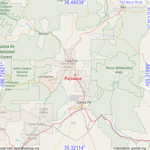
Pojoaque GPS coordinates[2]
35° 53' 34.08" North, 106° 1' 23.088" West
| Map corner | latitude | longitude |
|---|---|---|
| Upper-left | 36.46036°, | -106.72621° |
| Center: | 35.8928°, | -106.02308° |
| Lower-right: | 35.32114°, | -105.31996° |
| Map W x H: | 126.7×126.7 km | = 78.7×78.7mi |
| max Lat: | 71.29058° ⇑70.9% North |
| Pojoaque: | 35.8928° |
| min Lat: | ⇓29.1% South 19.06759° |
| min Long | Pojoaque | max Long |
| -171.73463° | -106.02308° | -66.98998° |
| W 16.1%⇐ | ⇒83.9% E |
Elevation
Elevation of Pojoaque is 1781 m = 5843 ft, and this is 1486.2 m = 4876 ft above average elevation for this country.
| Max E: |
3189 m = 10463 ft | 1.7% |
| Pojoaque | 1781 m 5843 ft | |
| Avg. | 294.8 m = 967 ft | |
Min E: |
-60 m = -197 ft | 98.3% |
See also: United States elevation on elevation.city.
Geographical zone
Pojoaque is located in North temperate zone (between Tropic of Cancer and the Arctic Circle). Distance of this Northern Tropic circle is 1385 km =860.6 mi to South.| Distance of | km | miles | from Pojoaque |
|---|---|---|---|
| North Pole | 6016.2 | 3738.3 | to North |
| Arctic Circle | 3410.3 | 2119.1 | to North |
| Tropic Cancer | 1385 | 860.6 | to South |
| Equator | 3990.9 | 2479.8 | to South |


Nearby cities:
15 places around Pojoaque: (largest is in red/bold)
• Chimayo
14.1 km =8.8 mi,  29°
29°
• El Rancho
5.1 km =3.2 mi,  265°
265°
• El Valle de Arroyo Seco
7.8 km =4.8 mi,  355°
355°
• Española
12.1 km =7.5 mi,  334°
334°
• Hernandez
20.8 km =12.9 mi,  335°
335°
• La Mesilla
7.5 km =4.7 mi, 325°
• La Puebla
11 km =6.8 mi,  12°
12°
• Nambe
3.7 km =2.3 mi,  89°
89°
• Ohkay Owingeh
18 km =11.2 mi,  346°
346°
• San Ildefonso Pueblo
8.6 km =5.3 mi, 269°
• San Jose
17.6 km =10.9 mi, 337°
• San Juan
18.2 km =11.3 mi, 347°
• Santa Clara Pueblo
10 km =6.2 mi,  323°
323°
• Tesuque
16.7 km =10.4 mi,  150°
150°
• White Rock
17.8 km =11.1 mi,  245°
245°
Sources, notices
• [Note1] Compared only with cities in United States existing in our database
• [Src1] Map data: © OpenStreetMap contributors (CC-BY-SA)
• [Src2] Other city data from geonames.org with taken over terms of usage.
• [Src3] Geographical zone / Annual Mean Temperature by Robert A. Rohde @ Wikipedia
