Wilsonville geodata
Wilsonville (Oregon) is a populated place; located in United States in America/Los_Angeles (GMT-7) time zone. With population of 22,729 people, there are 2228 cities with bigger population in this country. Compared to other cities in United States, 93.4% of cities are located further ↓South; 97.4% of cities are located further →East and 80.3% of cities have higher elevation than Wilsonville. Note1


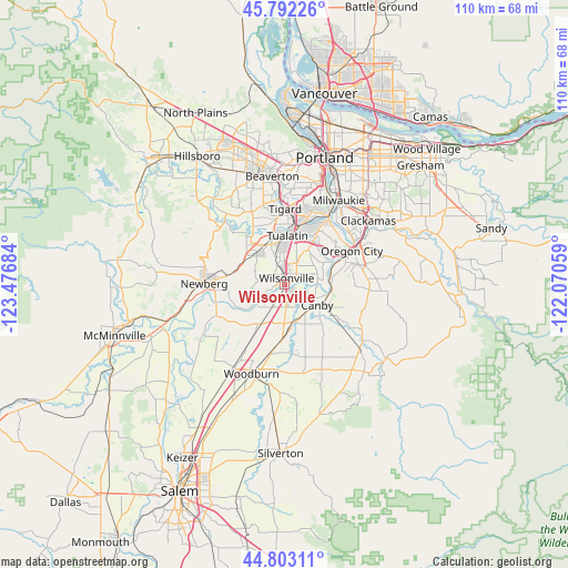
Wilsonville GPS coordinates[2]
45° 17' 59.424" North, 122° 46' 25.356" West
| Map corner | latitude | longitude |
|---|---|---|
| Upper-left | 45.79226°, | -123.47684° |
| Center: | 45.29984°, | -122.77371° |
| Lower-right: | 44.80311°, | -122.07059° |
| Map W x H: | 110×110 km | = 68.4×68.4mi |
| max Lat: | 71.29058° ⇑6.6% North |
| Wilsonville: | 45.29984° |
| min Lat: | ⇓93.4% South 19.06759° |
| min Long | Wilsonville | max Long |
| -171.73463° | -122.77371° | -66.98998° |
| W 2.6%⇐ | ⇒97.4% E |
Elevation
Elevation of Wilsonville is 45 m = 148 ft, and this is 249.8 m = 820 ft below average elevation for this country.
| Max E: |
3189 m = 10463 ft | 80.3% |
| Avg. | 294.8 m = 967 ft | |
| Wilsonville | 45 m = 148 ft | |
Min E: |
-60 m = -197 ft | 19.7% |
See also: United States elevation on elevation.city.
Geographical zone
Wilsonville is located in North temperate zone (between Tropic of Cancer and the Arctic Circle). Distance of this North polar circle is 2364.3 km =1469.1 mi to North.| Distance of | km | miles | from Wilsonville |
|---|---|---|---|
| North Pole | 4970.2 | 3088.3 | to North |
| Arctic Circle | 2364.3 | 1469.1 | to North |
| Tropic Cancer | 2431 | 1510.6 | to South |
| Equator | 5036.9 | 3129.8 | to South |


Nearby cities:
15 places around Wilsonville: (largest is in red/bold)
• Aurora
7.8 km =4.8 mi,  169°
169°
• Canby
7.6 km =4.7 mi,  122°
122°
• Donald
10 km =6.2 mi,  210°
210°
• Durham
11.5 km =7.1 mi,  8°
8°
• Hubbard
13.3 km =8.3 mi,  191°
191°
• Jennings Lodge
16.2 km =10.1 mi,  51°
51°
• King City
11.7 km =7.3 mi,  348°
348°
• Lake Oswego
15.7 km =9.8 mi,  30°
30°
• Newberg
15.6 km =9.7 mi,  270°
270°
• Oregon City
14.5 km =9 mi,  63°
63°
• Sherwood
8.2 km =5.1 mi,  320°
320°
• Stafford
7.5 km =4.7 mi, 32°
• Tigard
14.6 km =9.1 mi,  0°
0°
• Tualatin
9.4 km =5.8 mi, 4°
• West Linn
14.6 km =9.1 mi, 59°
Sources, notices
• [Note1] Compared only with cities in United States existing in our database
• [Src1] Map data: © OpenStreetMap contributors (CC-BY-SA)
• [Src2] Other city data from geonames.org with taken over terms of usage.
• [Src3] Geographical zone / Annual Mean Temperature by Robert A. Rohde @ Wikipedia
