Wimer geodata
Wimer (Oregon) is a populated place; located in United States in America/Los_Angeles (GMT-7) time zone. With population of 678 people, there are 18889 cities with bigger population in this country. Compared to other cities in United States, 80.1% of cities are located further ↓South; 98% of cities are located further →East and 79.6% of cities have lower elevation than Wimer. Note1


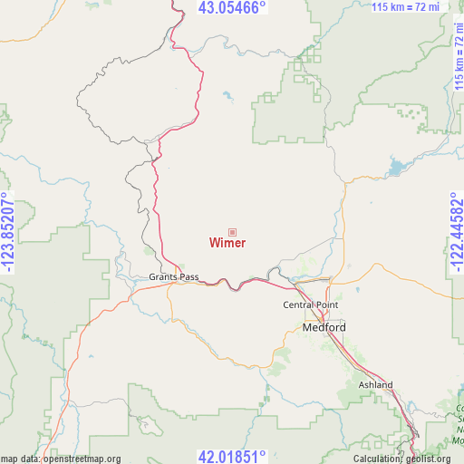
Wimer GPS coordinates[2]
42° 32' 19.428" North, 123° 8' 56.184" West
| Map corner | latitude | longitude |
|---|---|---|
| Upper-left | 43.05466°, | -123.85207° |
| Center: | 42.53873°, | -123.14894° |
| Lower-right: | 42.01851°, | -122.44582° |
| Map W x H: | 115.2×115.2 km | = 71.6×71.6mi |
| max Lat: | 71.29058° ⇑19.9% North |
| Wimer: | 42.53873° |
| min Lat: | ⇓80.1% South 19.06759° |
| min Long | Wimer | max Long |
| -171.73463° | -123.14894° | -66.98998° |
| W 2%⇐ | ⇒98% E |
Elevation
Elevation of Wimer is 349 m = 1145 ft, and this is 54.2 m = 178 ft above average elevation for this country.
| Max E: |
3189 m = 10463 ft | 20.4% |
| Wimer | 349 m 1145 ft | |
| Avg. | 294.8 m = 967 ft | |
Min E: |
-60 m = -197 ft | 79.6% |
See also: United States elevation on elevation.city.
Geographical zone
Wimer is located in North temperate zone (between Tropic of Cancer and the Arctic Circle). Distance of this Northern Tropic circle is 2123.9 km =1319.7 mi to South.| Distance of | km | miles | from Wimer |
|---|---|---|---|
| North Pole | 5277.2 | 3279.1 | to North |
| Arctic Circle | 2671.3 | 1659.9 | to North |
| Tropic Cancer | 2123.9 | 1319.7 | to South |
| Equator | 4729.9 | 2939 | to South |


Nearby cities:
15 places around Wimer: (largest is in red/bold)
• Central Point
26.3 km =16.3 mi,  133°
133°
• Eagle Point
29.3 km =18.2 mi,  104°
104°
• Foots Creek
14.9 km =9.3 mi,  176°
176°
• Fruitdale
18.4 km =11.4 mi,  225°
225°
• Glendale
31.4 km =19.5 mi,  314°
314°
• Gold Hill
14.4 km =8.9 mi,  145°
145°
• Grants Pass
18.6 km =11.6 mi, 233°
• Jacksonville
29.2 km =18.1 mi, 149°
• Merlin
22.3 km =13.9 mi,  263°
263°
• New Hope
26.6 km =16.5 mi,  222°
222°
• Redwood
23.5 km =14.6 mi,  236°
236°
• Rogue River
11.6 km =7.2 mi,  189°
189°
• Shady Cove
28.7 km =17.8 mi,  73°
73°
• Trail
30.3 km =18.8 mi, 66°
• White City
26.3 km =16.3 mi,  115°
115°
Sources, notices
• [Note1] Compared only with cities in United States existing in our database
• [Src1] Map data: © OpenStreetMap contributors (CC-BY-SA)
• [Src2] Other city data from geonames.org with taken over terms of usage.
• [Src3] Geographical zone / Annual Mean Temperature by Robert A. Rohde @ Wikipedia
