Ogden geodata
Ogden (Utah) is a seat of a second-order administrative division; located in United States in America/Denver (GMT-6) time zone. With population of 85,444 people, there are 452 cities with bigger population in this country. Compared to other cities in United States, 68% of cities are located further ↓South; 87.4% of cities are located further →East and 95.3% of cities have lower elevation than Ogden. Note1


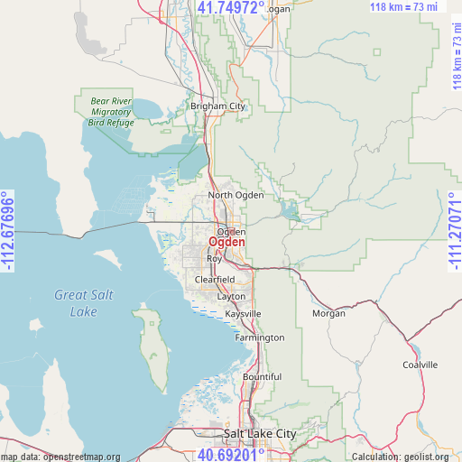
Ogden GPS coordinates[2]
41° 13' 22.8" North, 111° 58' 25.788" West
| Map corner | latitude | longitude |
|---|---|---|
| Upper-left | 41.74972°, | -112.67696° |
| Center: | 41.223°, | -111.97383° |
| Lower-right: | 40.69201°, | -111.27071° |
| Map W x H: | 117.6×117.6 km | = 73.1×73.1mi |
| max Lat: | 71.29058° ⇑32% North |
| Ogden: | 41.223° |
| min Lat: | ⇓68% South 19.06759° |
| min Long | Ogden | max Long |
| -171.73463° | -111.97383° | -66.98998° |
| W 12.6%⇐ | ⇒87.4% E |
Elevation
Elevation of Ogden is 1315 m = 4314 ft, and this is 1020.2 m = 3347 ft above average elevation for this country.
| Max E: |
3189 m = 10463 ft | 4.7% |
| Ogden | 1315 m 4314 ft | |
| Avg. | 294.8 m = 967 ft | |
Min E: |
-60 m = -197 ft | 95.3% |
See also: Ogden elevation on elevation.city.
Geographical zone
Ogden is located in North temperate zone (between Tropic of Cancer and the Arctic Circle). Distance of this Northern Tropic circle is 1977.6 km =1228.8 mi to South.| Distance of | km | miles | from Ogden |
|---|---|---|---|
| North Pole | 5423.5 | 3370 | to North |
| Arctic Circle | 2817.6 | 1750.8 | to North |
| Tropic Cancer | 1977.6 | 1228.8 | to South |
| Equator | 4583.6 | 2848.1 | to South |


Nearby cities:
15 places around Ogden: (largest is in red/bold)
• Clinton
11.3 km =7 mi,  214°
214°
• Farr West
9.4 km =5.8 mi,  331°
331°
• Harrisville
6.6 km =4.1 mi,  349°
349°
• Hill Air Force Base
12.4 km =7.7 mi,  181°
181°
• Marriott-Slaterville
5.4 km =3.4 mi,  306°
306°
• North Ogden
9.4 km =5.8 mi,  6°
6°
• Pleasant View
10.7 km =6.6 mi, 351°
• Riverdale
5.7 km =3.5 mi, 206°
• Roy
8.1 km =5 mi, 212°
• South Ogden
3.5 km =2.2 mi, 176°
• South Weber
10.7 km =6.6 mi,  160°
160°
• Sunset
10.8 km =6.7 mi, 206°
• Uintah
9.7 km =6 mi,  154°
154°
• Washington Terrace
5.6 km =3.5 mi, 182°
• West Haven
6.8 km =4.2 mi,  251°
251°
Sources, notices
• [Note1] Compared only with cities in United States existing in our database
• [Src1] Map data: © OpenStreetMap contributors (CC-BY-SA)
• [Src2] Other city data from geonames.org with taken over terms of usage.
• [Src3] Geographical zone / Annual Mean Temperature by Robert A. Rohde @ Wikipedia
