Orting geodata
Orting (Washington) is a populated place; located in United States in America/Los_Angeles (GMT-7) time zone. With population of 7,446 people, there are 5563 cities with bigger population in this country. Compared to other cities in United States, 96.8% of cities are located further ↓South; 95.7% of cities are located further →East and 77.3% of cities have higher elevation than Orting. Note1


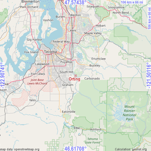
Orting GPS coordinates[2]
47° 5' 52.368" North, 122° 12' 15.408" West
| Map corner | latitude | longitude |
|---|---|---|
| Upper-left | 47.57438°, | -122.90741° |
| Center: | 47.09788°, | -122.20428° |
| Lower-right: | 46.61708°, | -121.50116° |
| Map W x H: | 106.4×106.4 km | = 66.1×66.1mi |
| max Lat: | 71.29058° ⇑3.2% North |
| Orting: | 47.09788° |
| min Lat: | ⇓96.8% South 19.06759° |
| min Long | Orting | max Long |
| -171.73463° | -122.20428° | -66.98998° |
| W 4.3%⇐ | ⇒95.7% E |
Elevation
Elevation of Orting is 59 m = 194 ft, and this is 235.8 m = 774 ft below average elevation for this country.
| Max E: |
3189 m = 10463 ft | 77.3% |
| Avg. | 294.8 m = 967 ft | |
| Orting | 59 m = 194 ft | |
Min E: |
-60 m = -197 ft | 22.7% |
See also: United States elevation on elevation.city.
Geographical zone
Orting is located in North temperate zone (between Tropic of Cancer and the Arctic Circle). Distance of this North polar circle is 2164.4 km =1344.9 mi to North.| Distance of | km | miles | from Orting |
|---|---|---|---|
| North Pole | 4770.3 | 2964.1 | to North |
| Arctic Circle | 2164.4 | 1344.9 | to North |
| Tropic Cancer | 2630.9 | 1634.8 | to South |
| Equator | 5236.8 | 3254 | to South |


Nearby cities:
15 places around Orting: (largest is in red/bold)
• Alderton
8.2 km =5.1 mi,  346°
346°
• Bonney Lake
8.9 km =5.5 mi,  8°
8°
• Carbonado
11.7 km =7.3 mi,  99°
99°
• Crocker
7.8 km =4.8 mi, 103°
• Frederickson
11.7 km =7.3 mi,  269°
269°
• Graham
8.5 km =5.3 mi,  233°
233°
• McMillin
5.3 km =3.3 mi,  332°
332°
• North Puyallup
13.5 km =8.4 mi, 334°
• Prairie Heights
9.4 km =5.8 mi,  52°
52°
• Prairie Ridge
6.1 km =3.8 mi,  43°
43°
• Puyallup
11.8 km =7.3 mi, 325°
• South Hill
6.9 km =4.3 mi,  314°
314°
• Summit
13.6 km =8.5 mi,  301°
301°
• Summit View
12 km =7.5 mi,  290°
290°
• Sumner
12 km =7.5 mi, 346°
Sources, notices
• [Note1] Compared only with cities in United States existing in our database
• [Src1] Map data: © OpenStreetMap contributors (CC-BY-SA)
• [Src2] Other city data from geonames.org with taken over terms of usage.
• [Src3] Geographical zone / Annual Mean Temperature by Robert A. Rohde @ Wikipedia
