Three Lakes geodata
Three Lakes (Washington) is a populated place; located in United States in America/Los_Angeles (GMT-7) time zone. With population of 3,184 people, there are 9325 cities with bigger population in this country. Compared to other cities in United States, 98.5% of cities are located further ↓South; 95.1% of cities are located further →East and 61.7% of cities have higher elevation than Three Lakes. Note1


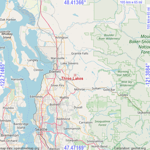
Three Lakes GPS coordinates[2]
47° 56' 41.352" North, 122° 0' 41.472" West
| Map corner | latitude | longitude |
|---|---|---|
| Upper-left | 48.41366°, | -122.71465° |
| Center: | 47.94482°, | -122.01152° |
| Lower-right: | 47.47169°, | -121.3084° |
| Map W x H: | 104.7×104.7 km | = 65.1×65.1mi |
| max Lat: | 71.29058° ⇑1.5% North |
| Three Lakes: | 47.94482° |
| min Lat: | ⇓98.5% South 19.06759° |
| min Long | Three Lakes | max Long |
| -171.73463° | -122.01152° | -66.98998° |
| W 4.9%⇐ | ⇒95.1% E |
Elevation
Elevation of Three Lakes is 146 m = 479 ft, and this is 148.8 m = 488 ft below average elevation for this country.
| Max E: |
3189 m = 10463 ft | 61.7% |
| Avg. | 294.8 m = 967 ft | |
| Three Lakes | 146 m = 479 ft | |
Min E: |
-60 m = -197 ft | 38.3% |
See also: United States elevation on elevation.city.
Geographical zone
Three Lakes is located in North temperate zone (between Tropic of Cancer and the Arctic Circle). Distance of this North polar circle is 2070.2 km =1286.4 mi to North.| Distance of | km | miles | from Three Lakes |
|---|---|---|---|
| North Pole | 4676.1 | 2905.6 | to North |
| Arctic Circle | 2070.2 | 1286.4 | to North |
| Tropic Cancer | 2725 | 1693.2 | to South |
| Equator | 5331 | 3312.5 | to South |


Nearby cities:
15 places around Three Lakes: (largest is in red/bold)
• Bunk Foss
6.5 km =4 mi,  286°
286°
• Cathcart
12.6 km =7.8 mi,  211°
211°
• Eastmont
13.7 km =8.5 mi,  247°
247°
• Fobes Hill
8.1 km =5 mi,  273°
273°
• Lake Bosworth
11.6 km =7.2 mi,  16°
16°
• Lake Roesiger
7.5 km =4.7 mi,  54°
54°
• Lake Stevens
8.7 km =5.4 mi,  333°
333°
• Lochsloy
12 km =7.5 mi,  352°
352°
• Machias
4.8 km =3 mi, 327°
• Monroe
10.4 km =6.5 mi,  163°
163°
• Monroe North
7.2 km =4.5 mi,  165°
165°
• Silver Firs
13.8 km =8.6 mi,  230°
230°
• Snohomish
7.4 km =4.6 mi,  241°
241°
• West Lake Stevens
8.6 km =5.3 mi,  308°
308°
• Woods Creek
11.2 km =7 mi,  131°
131°
Sources, notices
• [Note1] Compared only with cities in United States existing in our database
• [Src1] Map data: © OpenStreetMap contributors (CC-BY-SA)
• [Src2] Other city data from geonames.org with taken over terms of usage.
• [Src3] Geographical zone / Annual Mean Temperature by Robert A. Rohde @ Wikipedia
