‘Ele‘ele geodata
‘Ele‘ele (Hawaii) is a populated place; located in United States in Pacific/Honolulu (GMT-10) time zone. With population of 2,390 people, there are 10875 cities with bigger population in this country. Compared to other cities in United States, 99.4% of cities are located further ↑North; 99.8% of cities are located further →East and 82.3% of cities have higher elevation than ‘Ele‘ele. Note1


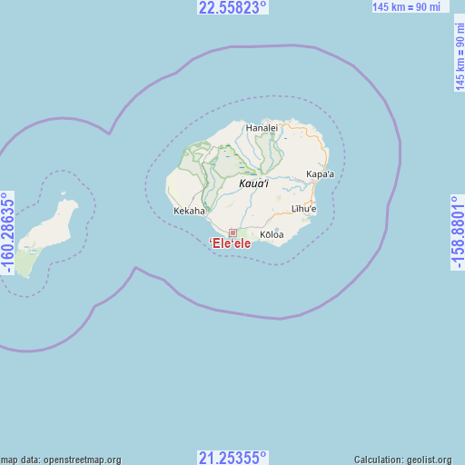
‘Ele‘ele GPS coordinates[2]
21° 54' 26.568" North, 159° 34' 59.592" West
| Map corner | latitude | longitude |
|---|---|---|
| Upper-left | 22.55823°, | -160.28635° |
| Center: | 21.90738°, | -159.58322° |
| Lower-right: | 21.25355°, | -158.8801° |
| Map W x H: | 145.1×145.1 km | = 90.2×90.2mi |
| max Lat: | 71.29058° ⇑99.4% North |
| ‘Ele‘ele: | 21.90738° |
| min Lat: | ⇓0.6% South 19.06759° |
| min Long | ‘Ele‘ele | max Long |
| -171.73463° | -159.58322° | -66.98998° |
| W 0.2%⇐ | ⇒99.8% E |
Elevation
Elevation of ‘Ele‘ele is 37 m = 121 ft, and this is 257.8 m = 846 ft below average elevation for this country.
| Max E: |
3189 m = 10463 ft | 82.3% |
| Avg. | 294.8 m = 967 ft | |
| ‘Ele‘ele | 37 m = 121 ft | |
Min E: |
-60 m = -197 ft | 17.7% |
See also: United States elevation on elevation.city.
Geographical zone
‘Ele‘ele is located in North Torrid zone (between Equator and Tropic of Cancer). Distance of this Northern Tropic circle is 170 km =105.6 mi to North.| Distance of | km | miles | from ‘Ele‘ele |
|---|---|---|---|
| North Pole | 7571.2 | 4704.5 | to North |
| Arctic Circle | 4965.3 | 3085.3 | to North |
| Tropic Cancer | 170 | 105.6 | to North |
| Equator | 2435.9 | 1513.6 | to South |


Nearby cities:
15 places around ‘Ele‘ele: (largest is in red/bold)
• Hanamā‘ulu
25.2 km =15.7 mi,  66°
66°
• Hanapēpē
1.2 km =0.7 mi,  269°
269°
• Hanapēpē Heights
1.2 km =0.7 mi,  325°
325°
• Kalāheo
6.1 km =3.8 mi, 72°
• Kaumakani
3.9 km =2.4 mi,  284°
284°
• Kekaha
14.8 km =9.2 mi,  296°
296°
• Koloa
11.7 km =7.3 mi,  90°
90°
• Lawai
8.3 km =5.2 mi,  79°
79°
• Lihue
23.3 km =14.5 mi, 69°
• Po‘ipū
14.4 km =8.9 mi,  105°
105°
• Puhi
20.1 km =12.5 mi, 70°
• Wailua
30 km =18.6 mi,  57°
57°
• Wailua Homesteads
28.1 km =17.5 mi,  49°
49°
• Waimea
10.4 km =6.5 mi, 302°
• ‘Ōma‘o
10 km =6.2 mi, 78°
Sources, notices
• [Note1] Compared only with cities in United States existing in our database
• [Src1] Map data: © OpenStreetMap contributors (CC-BY-SA)
• [Src2] Other city data from geonames.org with taken over terms of usage.
• [Src3] Geographical zone / Annual Mean Temperature by Robert A. Rohde @ Wikipedia
