Remsenburg-Speonk geodata
Remsenburg-Speonk (New York) is a populated place; located in United States in America/New_York (GMT-4) time zone. With population of 2,642 people, there are 10302 cities with bigger population in this country. Compared to other cities in United States, 63.6% of cities are located further ↓South; 94.4% of cities are located further ←West and 91% of cities have higher elevation than Remsenburg-Speonk. Note1


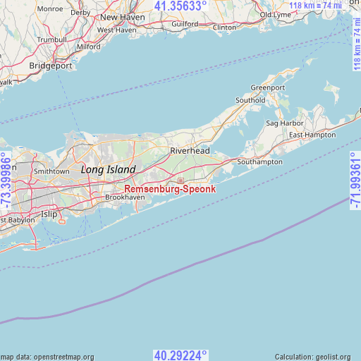
Remsenburg-Speonk GPS coordinates[2]
40° 49' 35.112" North, 72° 41' 48.228" West
| Map corner | latitude | longitude |
|---|---|---|
| Upper-left | 41.35633°, | -73.39986° |
| Center: | 40.82642°, | -72.69673° |
| Lower-right: | 40.29224°, | -71.99361° |
| Map W x H: | 118.3×118.3 km | = 73.5×73.5mi |
| max Lat: | 71.29058° ⇑36.4% North |
| Remsenburg-Speonk: | 40.82642° |
| min Lat: | ⇓63.6% South 19.06759° |
| min Long | Remsenburg-Speo | max Long |
| -171.73463° | -72.69673° | -66.98998° |
| W 94.4%⇐ | ⇒5.6% E |
Elevation
Elevation of Remsenburg-Speonk is 14 m = 46 ft, and this is 280.8 m = 921 ft below average elevation for this country.
| Max E: |
3189 m = 10463 ft | 91% |
| Avg. | 294.8 m = 967 ft | |
| Remsenburg-Speonk | 14 m = 46 ft | |
Min E: |
-60 m = -197 ft | 9% |
See also: United States elevation on elevation.city.
Geographical zone
Remsenburg-Speonk is located in North temperate zone (between Tropic of Cancer and the Arctic Circle). Distance of this Northern Tropic circle is 1933.6 km =1201.5 mi to South.| Distance of | km | miles | from Remsenburg-Speonk |
|---|---|---|---|
| North Pole | 5467.6 | 3397.4 | to North |
| Arctic Circle | 2861.7 | 1778.2 | to North |
| Tropic Cancer | 1933.6 | 1201.5 | to South |
| Equator | 4539.5 | 2820.7 | to South |


Nearby cities:
15 places around Remsenburg-Speonk: (largest is in red/bold)
• Calverton
9.7 km =6 mi,  336°
336°
• Center Moriches
8.4 km =5.2 mi,  249°
249°
• East Moriches
5.9 km =3.7 mi, 246°
• East Quogue
9.8 km =6.1 mi,  80°
80°
• Eastport
2.9 km =1.8 mi,  268°
268°
• Flanders
10.8 km =6.7 mi,  37°
37°
• Manorville
10.7 km =6.6 mi,  299°
299°
• Moriches
10.7 km =6.6 mi,  258°
258°
• Northampton
7 km =4.3 mi,  4°
4°
• Quiogue
5.7 km =3.5 mi,  97°
97°
• Quogue
7.3 km =4.5 mi,  92°
92°
• Riverhead
10.5 km =6.5 mi,  16°
16°
• Riverside
6.3 km =3.9 mi,  14°
14°
• Westhampton
2.6 km =1.6 mi, 94°
• Westhampton Beach
7.4 km =4.6 mi,  110°
110°
Sources, notices
• [Note1] Compared only with cities in United States existing in our database
• [Src1] Map data: © OpenStreetMap contributors (CC-BY-SA)
• [Src2] Other city data from geonames.org with taken over terms of usage.
• [Src3] Geographical zone / Annual Mean Temperature by Robert A. Rohde @ Wikipedia
