Lanham-Seabrook geodata
Lanham-Seabrook (Maryland) is a populated place; located in United States in America/New_York (GMT-4) time zone. With population of 18,190 people, there are 2757 cities with bigger population in this country. Compared to other cities in United States, 55.2% of cities are located further ↑North; 81.2% of cities are located further ←West and 78.4% of cities have higher elevation than Lanham-Seabrook. Note1


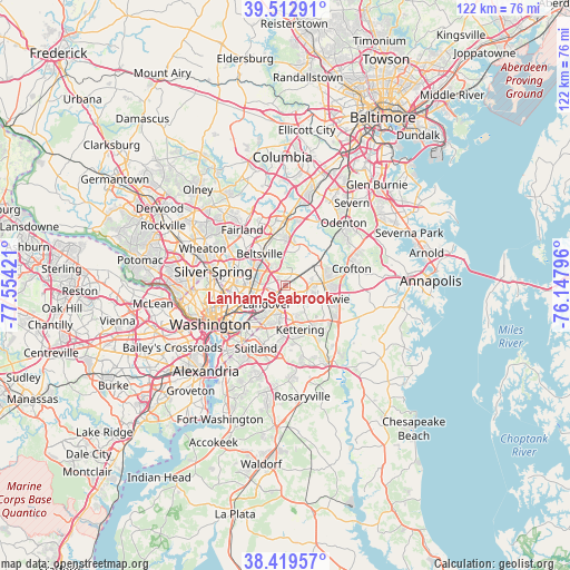
Lanham-Seabrook GPS coordinates[2]
38° 58' 6.06" North, 76° 51' 3.888" West
| Map corner | latitude | longitude |
|---|---|---|
| Upper-left | 39.51291°, | -77.55421° |
| Center: | 38.96835°, | -76.85108° |
| Lower-right: | 38.41957°, | -76.14796° |
| Map W x H: | 121.6×121.6 km | = 75.6×75.6mi |
| max Lat: | 71.29058° ⇑55.2% North |
| Lanham-Seabrook: | 38.96835° |
| min Lat: | ⇓44.8% South 19.06759° |
| min Long | Lanham-Seabrook | max Long |
| -171.73463° | -76.85108° | -66.98998° |
| W 81.2%⇐ | ⇒18.8% E |
Elevation
Elevation of Lanham-Seabrook is 54 m = 177 ft, and this is 240.8 m = 790 ft below average elevation for this country.
| Max E: |
3189 m = 10463 ft | 78.4% |
| Avg. | 294.8 m = 967 ft | |
| Lanham-Seabrook | 54 m = 177 ft | |
Min E: |
-60 m = -197 ft | 21.6% |
See also: United States elevation on elevation.city.
Geographical zone
Lanham-Seabrook is located in North temperate zone (between Tropic of Cancer and the Arctic Circle). Distance of this Northern Tropic circle is 1727 km =1073.1 mi to South.| Distance of | km | miles | from Lanham-Seabrook |
|---|---|---|---|
| North Pole | 5674.2 | 3525.8 | to North |
| Arctic Circle | 3068.3 | 1906.6 | to North |
| Tropic Cancer | 1727 | 1073.1 | to South |
| Equator | 4332.9 | 2692.3 | to South |


Nearby cities:
15 places around Lanham-Seabrook: (largest is in red/bold)
• Berwyn Heights
5.9 km =3.7 mi,  299°
299°
• East Riverdale
6.2 km =3.9 mi,  263°
263°
• Fairwood
6.5 km =4 mi,  101°
101°
• Glenarden
4.4 km =2.7 mi,  191°
191°
• Glenn Dale
3.4 km =2.1 mi,  50°
50°
• Goddard
2.4 km =1.5 mi,  355°
355°
• Greenbelt
4.5 km =2.8 mi,  332°
332°
• Landover
5.5 km =3.4 mi,  225°
225°
• Landover Hills
4.5 km =2.8 mi, 231°
• Lanham
1.1 km =0.7 mi,  272°
272°
• New Carrollton
2.5 km =1.6 mi, 273°
• Seabrook
0.4 km =0.2 mi,  94°
94°
• Springdale
3.6 km =2.2 mi,  162°
162°
• Woodlawn
4.1 km =2.5 mi,  239°
239°
• Woodmore
6.7 km =4.2 mi,  141°
141°
Sources, notices
• [Note1] Compared only with cities in United States existing in our database
• [Src1] Map data: © OpenStreetMap contributors (CC-BY-SA)
• [Src2] Other city data from geonames.org with taken over terms of usage.
• [Src3] Geographical zone / Annual Mean Temperature by Robert A. Rohde @ Wikipedia
