Suitland-Silver Hill geodata
Suitland-Silver Hill (Maryland) is a populated place; located in United States in America/New_York (GMT-4) time zone. With population of 33,515 people, there are 1479 cities with bigger population in this country. Compared to other cities in United States, 56.2% of cities are located further ↑North; 80.9% of cities are located further ←West and 72.5% of cities have higher elevation than Suitland-Silver Hill. Note1


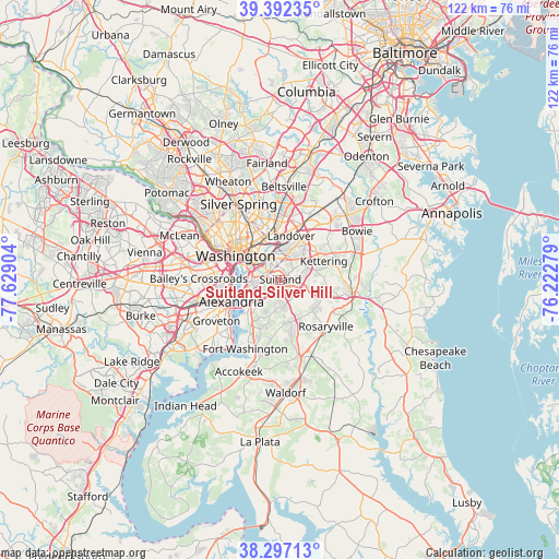
Suitland-Silver Hill GPS coordinates[2]
38° 50' 48.66" North, 76° 55' 33.276" West
| Map corner | latitude | longitude |
|---|---|---|
| Upper-left | 39.39235°, | -77.62904° |
| Center: | 38.84685°, | -76.92591° |
| Lower-right: | 38.29713°, | -76.22279° |
| Map W x H: | 121.8×121.8 km | = 75.7×75.7mi |
| max Lat: | 71.29058° ⇑56.2% North |
| Suitland-Silver Hill: | 38.84685° |
| min Lat: | ⇓43.8% South 19.06759° |
| min Long | Suitland-Silver | max Long |
| -171.73463° | -76.92591° | -66.98998° |
| W 80.9%⇐ | ⇒19.1% E |
Elevation
Elevation of Suitland-Silver Hill is 86 m = 282 ft, and this is 208.8 m = 685 ft below average elevation for this country.
| Max E: |
3189 m = 10463 ft | 72.5% |
| Avg. | 294.8 m = 967 ft | |
| Suitland-Silver Hill | 86 m = 282 ft | |
Min E: |
-60 m = -197 ft | 27.5% |
See also: United States elevation on elevation.city.
Geographical zone
Suitland-Silver Hill is located in North temperate zone (between Tropic of Cancer and the Arctic Circle). Distance of this Northern Tropic circle is 1713.4 km =1064.7 mi to South.| Distance of | km | miles | from Suitland-Silver Hill |
|---|---|---|---|
| North Pole | 5687.7 | 3534.2 | to North |
| Arctic Circle | 3081.8 | 1914.9 | to North |
| Tropic Cancer | 1713.4 | 1064.7 | to South |
| Equator | 4319.4 | 2683.9 | to South |


Nearby cities:
15 places around Suitland-Silver Hill: (largest is in red/bold)
• Camp Springs
5 km =3.1 mi,  160°
160°
• Capitol Heights
4.3 km =2.7 mi,  11°
11°
• Coral Hills
2.7 km =1.7 mi, 9°
• District Heights
3.4 km =2.1 mi,  69°
69°
• Fairmount Heights
6.1 km =3.8 mi, 8°
• Forestville
4.4 km =2.7 mi,  92°
92°
• Hillcrest Heights
3.3 km =2.1 mi,  241°
241°
• Marlow Heights
2.7 km =1.7 mi, 236°
• Morningside
3.5 km =2.2 mi,  121°
121°
• Peppermill Village
6.3 km =3.9 mi,  32°
32°
• Seat Pleasant
5.7 km =3.5 mi,  16°
16°
• Silver Hill
1.8 km =1.1 mi,  251°
251°
• Suitland
0.3 km =0.2 mi,  40°
40°
• Temple Hills
4 km =2.5 mi,  204°
204°
• Walker Mill
4.5 km =2.8 mi,  45°
45°
Sources, notices
• [Note1] Compared only with cities in United States existing in our database
• [Src1] Map data: © OpenStreetMap contributors (CC-BY-SA)
• [Src2] Other city data from geonames.org with taken over terms of usage.
• [Src3] Geographical zone / Annual Mean Temperature by Robert A. Rohde @ Wikipedia
