Picnic Point-North Lynnwood geodata
Picnic Point-North Lynnwood (Washington) is a populated place; located in United States in America/Los_Angeles (GMT-7) time zone. With population of 22,953 people, there are 2201 cities with bigger population in this country. Compared to other cities in United States, 98.4% of cities are located further ↓South; 96% of cities are located further →East and 60.3% of cities have higher elevation than Picnic Point-North Lynnwood. Note1
Current local time in Picnic Point-North Lynnwood:
03:08 AM, TuesdayDifference from your time zone: hours


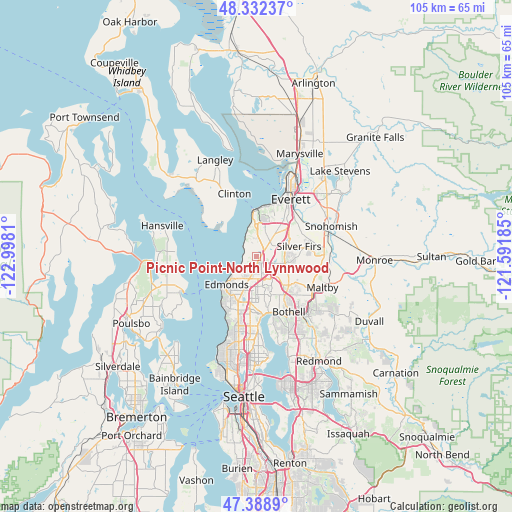
Picnic Point-North Lynnwood GPS coordinates[2]
47° 51' 46.008" North, 122° 17' 41.892" West
| Map corner | latitude | longitude |
|---|---|---|
| Upper-left | 48.33237°, | -122.9981° |
| Center: | 47.86278°, | -122.29497° |
| Lower-right: | 47.3889°, | -121.59185° |
| Map W x H: | 104.9×104.9 km | = 65.2×65.2mi |
| max Lat: | 71.29058° ⇑1.6% North |
| Picnic Point-North Lynnwood: | 47.86278° |
| min Lat: | ⇓98.4% South 19.06759° |
| min Long | Picnic Point-No | max Long |
| -171.73463° | -122.29497° | -66.98998° |
| W 4%⇐ | ⇒96% E |
Elevation
Elevation of Picnic Point-North Lynnwood is 153 m = 502 ft, and this is 141.8 m = 465 ft below average elevation for this country.
| Max E: |
3189 m = 10463 ft | 60.3% |
| Avg. | 294.8 m = 967 ft | |
| Picnic Point-North Lynnwood | 153 m = 502 ft | |
Min E: |
-60 m = -197 ft | 39.7% |
See also: United States elevation on elevation.city.
Geographical zone
Picnic Point-North Lynnwood is located in North temperate zone (between Tropic of Cancer and the Arctic Circle). Distance of this North polar circle is 2079.3 km =1292 mi to North.| Distance of | km | miles | from Picnic Point-North Lynnwood |
|---|---|---|---|
| North Pole | 4685.2 | 2911.2 | to North |
| Arctic Circle | 2079.3 | 1292 | to North |
| Tropic Cancer | 2715.9 | 1687.6 | to South |
| Equator | 5321.8 | 3306.8 | to South |


Nearby cities:
15 places around Picnic Point-North Lynnwood: (largest is in red/bold)
• Alderwood Manor
4.6 km =2.9 mi,  168°
168°
• Bothell West
7.6 km =4.7 mi,  147°
147°
• Brier
8.8 km =5.5 mi, 169°
• Eastmont
9.3 km =5.8 mi,  65°
65°
• Edmonds
8.5 km =5.3 mi,  226°
226°
• Lake Stickney
2.9 km =1.8 mi,  57°
57°
• Larch Way
3.8 km =2.4 mi,  125°
125°
• Lynnwood
4.9 km =3 mi,  197°
197°
• Martha Lake
4.4 km =2.7 mi,  107°
107°
• Meadowdale
3.1 km =1.9 mi,  249°
249°
• Mill Creek
6.8 km =4.2 mi,  92°
92°
• Mill Creek East
8.5 km =5.3 mi, 110°
• Mountlake Terrace
8.4 km =5.2 mi,  187°
187°
• Mukilteo
9.1 km =5.7 mi,  355°
355°
• Picnic Point
3.2 km =2 mi,  309°
309°
Sources, notices
• [Note1] Compared only with cities in United States existing in our database
• [Src1] Map data: © OpenStreetMap contributors (CC-BY-SA)
• [Src2] Other city data from geonames.org with taken over terms of usage.
• [Src3] Geographical zone / Annual Mean Temperature by Robert A. Rohde @ Wikipedia
