Hide-A-Way Lake geodata
Hide-A-Way Lake (Mississippi) is a populated place; located in United States in America/Chicago (GMT-5) time zone. With population of 1,859 people, there are 12344 cities with bigger population in this country. Compared to other cities in United States, 91.6% of cities are located further ↑North; 58% of cities are located further →East and 81.3% of cities have higher elevation than Hide-A-Way Lake. Note1


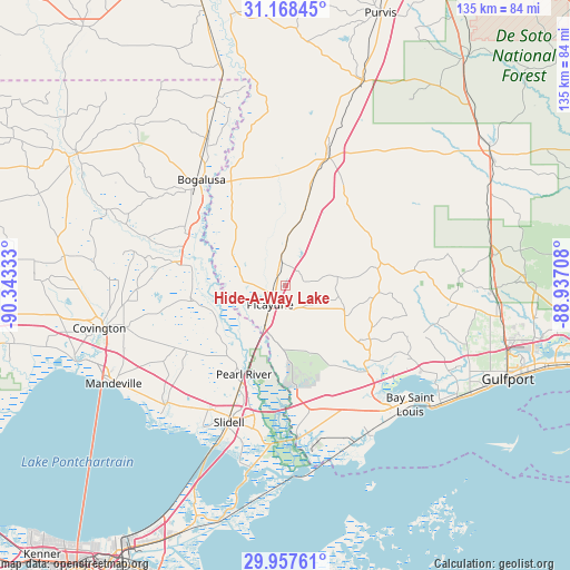
Hide-A-Way Lake GPS coordinates[2]
30° 33' 53.712" North, 89° 38' 24.72" West
| Map corner | latitude | longitude |
|---|---|---|
| Upper-left | 31.16845°, | -90.34333° |
| Center: | 30.56492°, | -89.6402° |
| Lower-right: | 29.95761°, | -88.93708° |
| Map W x H: | 134.6×134.6 km | = 83.6×83.6mi |
| max Lat: | 71.29058° ⇑91.6% North |
| Hide-A-Way Lake: | 30.56492° |
| min Lat: | ⇓8.4% South 19.06759° |
| min Long | Hide-A-Way Lake | max Long |
| -171.73463° | -89.6402° | -66.98998° |
| W 42%⇐ | ⇒58% E |
Elevation
Elevation of Hide-A-Way Lake is 41 m = 135 ft, and this is 253.8 m = 833 ft below average elevation for this country.
| Max E: |
3189 m = 10463 ft | 81.3% |
| Avg. | 294.8 m = 967 ft | |
| Hide-A-Way Lake | 41 m = 135 ft | |
Min E: |
-60 m = -197 ft | 18.7% |
See also: United States elevation on elevation.city.
Geographical zone
Hide-A-Way Lake is located in North temperate zone (between Tropic of Cancer and the Arctic Circle). Distance of this Northern Tropic circle is 792.6 km =492.5 mi to South.| Distance of | km | miles | from Hide-A-Way Lake |
|---|---|---|---|
| North Pole | 6608.6 | 4106.4 | to North |
| Arctic Circle | 4002.7 | 2487.2 | to North |
| Tropic Cancer | 792.6 | 492.5 | to South |
| Equator | 3398.5 | 2111.7 | to South |


Nearby cities:
15 places around Hide-A-Way Lake: (largest is in red/bold)
• Abita Springs
39.5 km =24.5 mi,  255°
255°
• Bay Saint Louis
41.2 km =25.6 mi,  133°
133°
• Bogalusa
32.1 km =19.9 mi,  321°
321°
• Carriere
5.9 km =3.7 mi,  348°
348°
• Diamondhead
32.5 km =20.2 mi, 125°
• Eden Isle
40.4 km =25.1 mi,  202°
202°
• Kiln
26.2 km =16.3 mi, 131°
• Lacombe
40.3 km =25 mi,  226°
226°
• Nicholson
11 km =6.8 mi,  207°
207°
• Pearl River
23.4 km =14.5 mi, 206°
• Pearlington
35.5 km =22.1 mi,  175°
175°
• Picayune
5.7 km =3.5 mi,  219°
219°
• Poplarville
32.2 km =20 mi,  18°
18°
• Slidell
34.9 km =21.7 mi, 202°
• Waveland
40 km =24.9 mi,  140°
140°
Sources, notices
• [Note1] Compared only with cities in United States existing in our database
• [Src1] Map data: © OpenStreetMap contributors (CC-BY-SA)
• [Src2] Other city data from geonames.org with taken over terms of usage.
• [Src3] Geographical zone / Annual Mean Temperature by Robert A. Rohde @ Wikipedia
