Port Elizabeth geodata
Port Elizabeth (Grenadines) is a seat of a first-order administrative division; located in Saint Vincent and the Grenadines in America/St_Vincent (GMT-4) time zone. With population of 839 people, there are 6 cities with bigger population in this country. Compared to other cities in Saint Vincent and the Grenadines, 88.9% of cities are located further ↑North; 66.7% of cities are located further →East and 66.7% of cities have higher elevation than Port Elizabeth. Note1


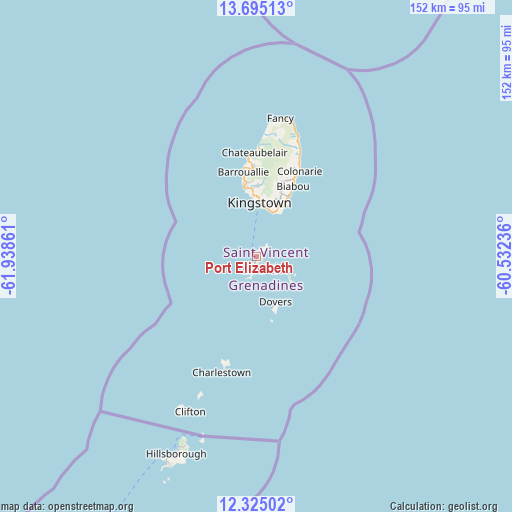
Port Elizabeth GPS coordinates[2]
13° 0' 39.672" North, 61° 14' 7.728" West
| Map corner | latitude | longitude |
|---|---|---|
| Upper-left | 13.69513°, | -61.93861° |
| Center: | 13.01102°, | -61.23548° |
| Lower-right: | 12.32502°, | -60.53236° |
| Map W x H: | 152.3×152.3 km | = 94.6×94.6mi |
| max Lat: | 13.29069° ⇑88.9% North |
| Port Elizabeth: | 13.01102° |
| min Lat: | ⇓11.1% South 12.89186° |
| min Long | Port Elizabeth | max Long |
| -61.27275° | -61.23548° | -61.1185° |
| W 33.3%⇐ | ⇒66.7% E |
Elevation
Elevation of Port Elizabeth is 10 m = 33 ft, and this is 4.2 m = 14 ft below average elevation for this country.
| Max E: |
24 m = 79 ft | 66.7% |
| Avg. | 14.2 m = 47 ft | |
| Port Elizabeth | 10 m = 33 ft | |
Min E: |
9 m = 30 ft | 33.3% |
See also: Saint Vincent and the Grenadines elevation on elevation.city.
Geographical zone
Port Elizabeth is located in North Torrid zone (between Equator and Tropic of Cancer). Distance of this Northern Tropic circle is 1159.2 km =720.3 mi to North.| Distance of | km | miles | from Port Elizabeth |
|---|---|---|---|
| North Pole | 8560.4 | 5319.2 | to North |
| Arctic Circle | 5954.5 | 3700 | to North |
| Tropic Cancer | 1159.2 | 720.3 | to North |
| Equator | 1446.7 | 898.9 | to South |


Nearby cities:
9 places around Port Elizabeth: (largest is in red/bold)
• Barrouallie
25.4 km =15.8 mi,  350°
350°
• Biabou
22.9 km =14.2 mi,  27°
27°
• Byera Village
30 km =18.6 mi,  24°
24°
• Chateaubelair
31.1 km =19.3 mi,  359°
359°
• Dovers
14.3 km =8.9 mi,  157°
157°
• Georgetown
32.5 km =20.2 mi, 22°
• Kingstown
16.1 km =10 mi,  3°
3°
• Kingstown Park
16.5 km =10.3 mi, 1°
• Layou
21.5 km =13.4 mi, 349°
Sources, notices
• [Note1] Compared only with cities in Saint Vincent and the Grenadines existing in our database
• [Src1] Map data: © OpenStreetMap contributors (CC-BY-SA)
• [Src2] Other city data from geonames.org with taken over terms of usage.
• [Src3] Geographical zone / Annual Mean Temperature by Robert A. Rohde @ Wikipedia
