Lotofaga geodata
Lotofaga (Atua) is a populated place; located in Samoa in Pacific/Apia (GMT+13) time zone. With population of 622 people, there are 43 cities with bigger population in this country. Compared to other cities in Samoa, 98.4% of cities are located further ↑North; 90.2% of cities are located further ←West and 85.2% of cities have lower elevation than Lotofaga. Note1


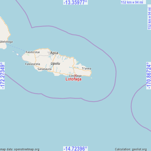
Lotofaga GPS coordinates[2]
14° 2' 34.368" South, 171° 34' 13.296" West
| Map corner | latitude | longitude |
|---|---|---|
| Upper-left | -13.35977°, | -172.27349° |
| Center: | -14.04288°, | -171.57036° |
| Lower-right: | -14.72396°, | -170.86724° |
| Map W x H: | 151.7×151.7 km | = 94.3×94.3mi |
| max Lat: | -13.44894° ⇑98.4% North |
| Lotofaga: | -14.04288° |
| min Lat: | ⇓1.6% South -14.04454° |
| min Long | Lotofaga | max Long |
| -172.69436° | -171.57036° | -171.42559° |
| W 90.2%⇐ | ⇒9.8% E |
Elevation
Elevation of Lotofaga is 25 m = 82 ft, and this is 1.1 m = 4 ft above average elevation for this country.
| Max E: |
252 m = 827 ft | 14.8% |
| Lotofaga | 25 m 82 ft | |
| Avg. | 23.9 m = 78 ft | |
Min E: |
7 m = 23 ft | 85.2% |
See also: Samoa elevation on elevation.city.
Geographical zone
Lotofaga is located in South Torrid zone (between Equator and Tropic of Capricorn). Distance of this Southern Tropic circle is 1044.5 km =649 mi to South.| Distance of | km | miles | from Lotofaga |
|---|---|---|---|
| Equator | 1561.4 | 970.2 | to North |
| Tropic Capricorn | 1044.5 | 649 | to South |
| Antarctic Circle | 5839.8 | 3628.7 | to South |
| South Pole | 8445.6 | 5247.9 | to South |


Nearby cities:
15 places around Lotofaga: (largest is in red/bold)
• Faleapuna
18.5 km =11.5 mi,  352°
352°
• Falefa
17.4 km =10.8 mi, 353°
• Falevao
13.7 km =8.5 mi, 352°
• Fusi
18.3 km =11.4 mi,  342°
342°
• Lalomanu
14.1 km =8.8 mi,  90°
90°
• Lufilufi
19 km =11.8 mi, 350°
• Matautu
11.6 km =7.2 mi,  272°
272°
• Matavai
8.4 km =5.2 mi,  278°
278°
• Salani
4.8 km =3 mi,  4°
4°
• Saleilua
13.9 km =8.6 mi, 276°
• Sale’a’aumua
16.1 km =10 mi,  76°
76°
• Samamea
12.8 km =8 mi,  19°
19°
• Samusu
16.2 km =10.1 mi,  73°
73°
• Satitoa
15.2 km =9.4 mi, 83°
• Vaovai
11.8 km =7.3 mi, 273°
Sources, notices
• [Note1] Compared only with cities in Samoa existing in our database
• [Src1] Map data: © OpenStreetMap contributors (CC-BY-SA)
• [Src2] Other city data from geonames.org with taken over terms of usage.
• [Src3] Geographical zone / Annual Mean Temperature by Robert A. Rohde @ Wikipedia
