Cedar Grove geodata
Cedar Grove (Saint John) is a populated place; located in Antigua and Barbuda in America/Antigua (GMT-4) time zone. With population of 789 people, there are 9 cities with bigger population in this country. Compared to other cities in Antigua and Barbuda, 92.9% of cities are located further ↓South; 64.3% of cities are located further →East and 100% of cities have higher elevation than Cedar Grove. Note1


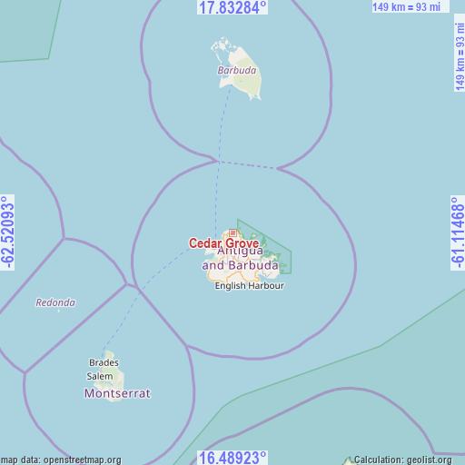
Cedar Grove GPS coordinates[2]
17° 9' 44.1" North, 61° 49' 4.08" West
| Map corner | latitude | longitude |
|---|---|---|
| Upper-left | 17.83284°, | -62.52093° |
| Center: | 17.16225°, | -61.8178° |
| Lower-right: | 16.48923°, | -61.11468° |
| Map W x H: | 149.4×149.4 km | = 92.8×92.8mi |
| max Lat: | 17.63333° ⇑7.1% North |
| Cedar Grove: | 17.16225° |
| min Lat: | ⇓92.9% South 17.01637° |
| min Long | Cedar Grove | max Long |
| -61.87466° | -61.8178° | -61.70332° |
| W 35.7%⇐ | ⇒64.3% E |
Elevation
Elevation of Cedar Grove is 1 m = 3 ft, and this is 9.9 m = 32 ft below average elevation for this country.
| Max E: |
60 m = 197 ft | 100% |
| Avg. | 10.9 m = 36 ft | |
| Cedar Grove | 1 m = 3 ft | |
Min E: |
1 m = 3 ft | 0% |
See also: Antigua and Barbuda elevation on elevation.city.
Geographical zone
Cedar Grove is located in North Torrid zone (between Equator and Tropic of Cancer). Distance of this Northern Tropic circle is 697.7 km =433.5 mi to North.| Distance of | km | miles | from Cedar Grove |
|---|---|---|---|
| North Pole | 8098.8 | 5032.4 | to North |
| Arctic Circle | 5492.9 | 3413.1 | to North |
| Tropic Cancer | 697.7 | 433.5 | to North |
| Equator | 1908.3 | 1185.8 | to South |


Nearby cities:
14 places around Cedar Grove: (largest is in red/bold)
• All Saints
10.9 km =6.8 mi,  166°
166°
• Bolands
12.3 km =7.6 mi,  209°
209°
• Carlisle
3.7 km =2.3 mi,  155°
155°
• Codrington
52.4 km =32.6 mi,  358°
358°
• English Harbour Town
17.1 km =10.6 mi, 161°
• Falmouth
15.5 km =9.6 mi, 165°
• Freetown
17.6 km =10.9 mi,  136°
136°
• Liberta
13.7 km =8.5 mi, 167°
• Old Road
16.3 km =10.1 mi,  186°
186°
• Parham
8.8 km =5.5 mi,  145°
145°
• Piggotts
5.4 km =3.4 mi, 159°
• Potters Village
5.4 km =3.4 mi,  182°
182°
• Saint John’s
5.3 km =3.3 mi, 210°
• Swetes
12.6 km =7.8 mi, 171°
Sources, notices
• [Note1] Compared only with cities in Antigua and Barbuda existing in our database
• [Src1] Map data: © OpenStreetMap contributors (CC-BY-SA)
• [Src2] Other city data from geonames.org with taken over terms of usage.
• [Src3] Geographical zone / Annual Mean Temperature by Robert A. Rohde @ Wikipedia
