Papër geodata
Papër (Elbasan) is a seat of a third-order administrative division; located in Albania in Europe/Tirane (GMT+2) time zone. In our database, there are 71 cities with bigger population. Compared to other cities in Albania, 50.7% of cities are located further ↓South; 52.1% of cities are located further →East and 69.6% of cities have higher elevation than Papër. Note1


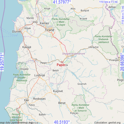
Papër GPS coordinates[2]
41° 3' 6.012" North, 19° 57' 38.988" East
| Map corner | latitude | longitude |
|---|---|---|
| Upper-left | 41.57977°, | 19.25771° |
| Center: | 41.05167°, | 19.96083° |
| Lower-right: | 40.5193°, | 20.66396° |
| Map W x H: | 117.9×117.9 km | = 73.3×73.3mi |
| max Lat: | 42.45139° ⇑49.3% North |
| Papër: | 41.05167° |
| min Lat: | ⇓50.7% South 39.65889° |
| min Long | Papër | max Long |
| 19.40556° | 19.96083° | 20.99° |
| W 47.9%⇐ | ⇒52.1% E |
Elevation
Elevation of Papër is 85 m = 279 ft, and this is 289.6 m = 950 ft below average elevation for this country.
| Max E: |
1352 m = 4436 ft | 69.6% |
| Avg. | 374.6 m = 1229 ft | |
| Papër | 85 m = 279 ft | |
Min E: |
-2 m = -7 ft | 30.4% |
See also: Albania elevation on elevation.city.
Geographical zone
Papër is located in North temperate zone (between Tropic of Cancer and the Arctic Circle). Distance of this Northern Tropic circle is 1958.6 km =1217 mi to South.| Distance of | km | miles | from Papër |
|---|---|---|---|
| North Pole | 5442.5 | 3381.8 | to North |
| Arctic Circle | 2836.7 | 1762.6 | to North |
| Tropic Cancer | 1958.6 | 1217 | to South |
| Equator | 4564.5 | 2836.2 | to South |


Nearby cities:
15 places around Papër: (largest is in red/bold)
• Belsh
10.8 km =6.7 mi,  217°
217°
• Bradashesh
7.9 km =4.9 mi,  41°
41°
• Cërrik
2.6 km =1.6 mi,  150°
150°
• Elbasan
12.2 km =7.6 mi,  56°
56°
• Gjergjan
5.9 km =3.7 mi,  99°
99°
• Gracen
11.2 km =7 mi,  1°
1°
• Grekan
13.6 km =8.5 mi,  184°
184°
• Klos
12.4 km =7.7 mi,  160°
160°
• Mollas
14.3 km =8.9 mi,  165°
165°
• Pajovë
10.3 km =6.4 mi,  271°
271°
• Përparim
13.6 km =8.5 mi, 269°
• Shalës
6 km =3.7 mi,  190°
190°
• Shezë
12.5 km =7.8 mi,  255°
255°
• Shirgjan
7.8 km =4.8 mi,  89°
89°
• Tregan
10.3 km =6.4 mi,  106°
106°
Sources, notices
• [Note1] Compared only with cities in Albania existing in our database
• [Src1] Map data: © OpenStreetMap contributors (CC-BY-SA)
• [Src2] Other city data from geonames.org with taken over terms of usage.
• [Src3] Geographical zone / Annual Mean Temperature by Robert A. Rohde @ Wikipedia
