Bradashesh geodata
Bradashesh (Elbasan) is a seat of a third-order administrative division; located in Albania in Europe/Tirane (GMT+2) time zone. In our database, there are 71 cities with bigger population. Compared to other cities in Albania, 54.6% of cities are located further ↓South; 54.1% of cities are located further ←West and 66.5% of cities have higher elevation than Bradashesh. Note1


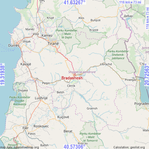
Bradashesh GPS coordinates[2]
41° 6' 18" North, 20° 1' 21" East
| Map corner | latitude | longitude |
|---|---|---|
| Upper-left | 41.63267°, | 19.31938° |
| Center: | 41.105°, | 20.0225° |
| Lower-right: | 40.57306°, | 20.72563° |
| Map W x H: | 117.8×117.8 km | = 73.2×73.2mi |
| max Lat: | 42.45139° ⇑45.4% North |
| Bradashesh: | 41.105° |
| min Lat: | ⇓54.6% South 39.65889° |
| min Long | Bradashesh | max Long |
| 19.40556° | 20.0225° | 20.99° |
| W 54.1%⇐ | ⇒45.9% E |
Elevation
Elevation of Bradashesh is 112 m = 367 ft, and this is 262.6 m = 862 ft below average elevation for this country.
| Max E: |
1352 m = 4436 ft | 66.5% |
| Avg. | 374.6 m = 1229 ft | |
| Bradashesh | 112 m = 367 ft | |
Min E: |
-2 m = -7 ft | 33.5% |
See also: Albania elevation on elevation.city.
Geographical zone
Bradashesh is located in North temperate zone (between Tropic of Cancer and the Arctic Circle). Distance of this Northern Tropic circle is 1964.5 km =1220.7 mi to South.| Distance of | km | miles | from Bradashesh |
|---|---|---|---|
| North Pole | 5436.6 | 3378.1 | to North |
| Arctic Circle | 2830.7 | 1758.9 | to North |
| Tropic Cancer | 1964.5 | 1220.7 | to South |
| Equator | 4570.4 | 2839.9 | to South |


Nearby cities:
15 places around Bradashesh: (largest is in red/bold)
• Cërrik
9 km =5.6 mi,  205°
205°
• Elbasan
5.1 km =3.2 mi,  80°
80°
• Funarë
10.6 km =6.6 mi,  17°
17°
• Gjergjan
6.9 km =4.3 mi,  174°
174°
• Gjinar
16.7 km =10.4 mi,  123°
123°
• Gracen
7.2 km =4.5 mi,  316°
316°
• Krrabë
13 km =8.1 mi,  340°
340°
• Labinot-Fushë
11.1 km =6.9 mi,  69°
69°
• Labinot-Mal
15.2 km =9.4 mi,  45°
45°
• Pajovë
16.5 km =10.3 mi,  250°
250°
• Papër
7.9 km =4.9 mi,  221°
221°
• Shalës
13.4 km =8.3 mi, 207°
• Shirgjan
6.4 km =4 mi,  156°
156°
• Shushicë
10.6 km =6.6 mi,  94°
94°
• Tregan
10.1 km =6.3 mi,  152°
152°
Sources, notices
• [Note1] Compared only with cities in Albania existing in our database
• [Src1] Map data: © OpenStreetMap contributors (CC-BY-SA)
• [Src2] Other city data from geonames.org with taken over terms of usage.
• [Src3] Geographical zone / Annual Mean Temperature by Robert A. Rohde @ Wikipedia
