Ballsh geodata
Ballsh (Fier) is a seat of a second-order administrative division; located in Albania in Europe/Tirane (GMT+2) time zone. With population of 10,361 people, there are 34 cities with bigger population in this country. Compared to other cities in Albania, 79.7% of cities are located further ↑North; 72.7% of cities are located further →East and 56.3% of cities have higher elevation than Ballsh. Note1


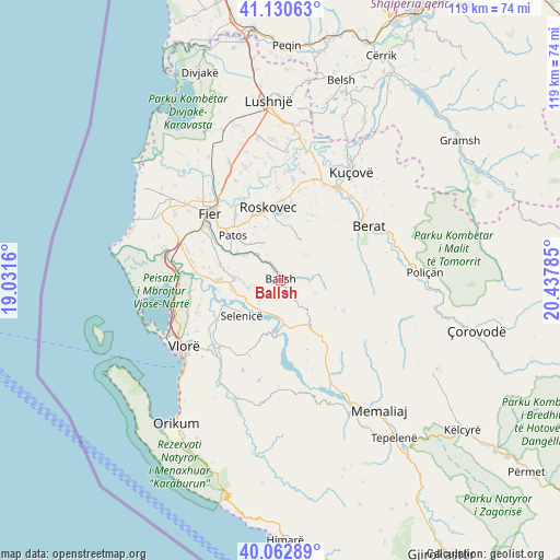
Ballsh GPS coordinates[2]
40° 35' 56.004" North, 19° 44' 4.992" East
| Map corner | latitude | longitude |
|---|---|---|
| Upper-left | 41.13063°, | 19.0316° |
| Center: | 40.59889°, | 19.73472° |
| Lower-right: | 40.06289°, | 20.43785° |
| Map W x H: | 118.7×118.7 km | = 73.8×73.8mi |
| max Lat: | 42.45139° ⇑79.7% North |
| Ballsh: | 40.59889° |
| min Lat: | ⇓20.3% South 39.65889° |
| min Long | Ballsh | max Long |
| 19.40556° | 19.73472° | 20.99° |
| W 27.3%⇐ | ⇒72.7% E |
Elevation
Elevation of Ballsh is 206 m = 676 ft, and this is 168.6 m = 553 ft below average elevation for this country.
| Max E: |
1352 m = 4436 ft | 56.3% |
| Avg. | 374.6 m = 1229 ft | |
| Ballsh | 206 m = 676 ft | |
Min E: |
-2 m = -7 ft | 43.7% |
See also: Albania elevation on elevation.city.
Geographical zone
Ballsh is located in North temperate zone (between Tropic of Cancer and the Arctic Circle). Distance of this Northern Tropic circle is 1908.3 km =1185.8 mi to South.| Distance of | km | miles | from Ballsh |
|---|---|---|---|
| North Pole | 5492.9 | 3413.1 | to North |
| Arctic Circle | 2887 | 1793.9 | to North |
| Tropic Cancer | 1908.3 | 1185.8 | to South |
| Equator | 4514.2 | 2805 | to South |


Nearby cities:
15 places around Ballsh: (largest is in red/bold)
• Aranitas
6.1 km =3.8 mi,  94°
94°
• Cakran
9.2 km =5.7 mi,  273°
273°
• Drenovë
2.9 km =1.8 mi, 273°
• Fratar
13 km =8.1 mi,  147°
147°
• Greshicë
6.4 km =4 mi,  144°
144°
• Hekal
4.1 km =2.5 mi,  178°
178°
• Kalenjë
3.8 km =2.4 mi,  105°
105°
• Kurjan
13.2 km =8.2 mi,  3°
3°
• Ngraçan
7 km =4.3 mi,  43°
43°
• Patos
13.5 km =8.4 mi,  313°
313°
• Patos Fshat
8.6 km =5.3 mi,  304°
304°
• Ruzhdie
8.6 km =5.3 mi,  338°
338°
• Selenicë
11.3 km =7 mi,  227°
227°
• Selitë
11.1 km =6.9 mi,  120°
120°
• Sinjë
12.5 km =7.8 mi,  64°
64°
Sources, notices
• [Note1] Compared only with cities in Albania existing in our database
• [Src1] Map data: © OpenStreetMap contributors (CC-BY-SA)
• [Src2] Other city data from geonames.org with taken over terms of usage.
• [Src3] Geographical zone / Annual Mean Temperature by Robert A. Rohde @ Wikipedia
