Kurjan geodata
Kurjan (Fier) is a seat of a third-order administrative division; located in Albania in Europe/Tirane (GMT+2) time zone. In our database, there are 71 cities with bigger population. Compared to other cities in Albania, 71% of cities are located further ↑North; 71.3% of cities are located further →East and 65.6% of cities have higher elevation than Kurjan. Note1


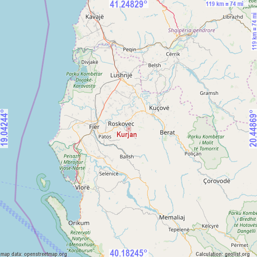
Kurjan GPS coordinates[2]
40° 43' 3" North, 19° 44' 44.016" East
| Map corner | latitude | longitude |
|---|---|---|
| Upper-left | 41.24829°, | 19.04244° |
| Center: | 40.7175°, | 19.74556° |
| Lower-right: | 40.18245°, | 20.44869° |
| Map W x H: | 118.5×118.5 km | = 73.6×73.6mi |
| max Lat: | 42.45139° ⇑71% North |
| Kurjan: | 40.7175° |
| min Lat: | ⇓29% South 39.65889° |
| min Long | Kurjan | max Long |
| 19.40556° | 19.74556° | 20.99° |
| W 28.7%⇐ | ⇒71.3% E |
Elevation
Elevation of Kurjan is 116 m = 381 ft, and this is 258.6 m = 848 ft below average elevation for this country.
| Max E: |
1352 m = 4436 ft | 65.6% |
| Avg. | 374.6 m = 1229 ft | |
| Kurjan | 116 m = 381 ft | |
Min E: |
-2 m = -7 ft | 34.4% |
See also: Albania elevation on elevation.city.
Geographical zone
Kurjan is located in North temperate zone (between Tropic of Cancer and the Arctic Circle). Distance of this Northern Tropic circle is 1921.4 km =1193.9 mi to South.| Distance of | km | miles | from Kurjan |
|---|---|---|---|
| North Pole | 5479.7 | 3404.9 | to North |
| Arctic Circle | 2873.8 | 1785.7 | to North |
| Tropic Cancer | 1921.4 | 1193.9 | to South |
| Equator | 4527.4 | 2813.2 | to South |


Nearby cities:
15 places around Kurjan: (largest is in red/bold)
• Ballsh
13.2 km =8.2 mi,  183°
183°
• Cukalat
4 km =2.5 mi,  69°
69°
• Dushk
1.4 km =0.9 mi,  43°
43°
• Kuman
5.1 km =3.2 mi,  281°
281°
• Kutalli
8.2 km =5.1 mi,  25°
25°
• Ngraçan
9 km =5.6 mi,  154°
154°
• Patos
11.3 km =7 mi,  250°
250°
• Patos Fshat
11.5 km =7.1 mi,  223°
223°
• Poshnje
10.9 km =6.8 mi,  49°
49°
• Roskovec
4.3 km =2.7 mi,  301°
301°
• Ruzhdie
6.5 km =4 mi, 217°
• Sinjë
12.9 km =8 mi,  126°
126°
• Strum
3.8 km =2.4 mi,  349°
349°
• Ura Vajgurore
12.5 km =7.8 mi,  62°
62°
• Zharrëz
8.1 km =5 mi,  263°
263°
Sources, notices
• [Note1] Compared only with cities in Albania existing in our database
• [Src1] Map data: © OpenStreetMap contributors (CC-BY-SA)
• [Src2] Other city data from geonames.org with taken over terms of usage.
• [Src3] Geographical zone / Annual Mean Temperature by Robert A. Rohde @ Wikipedia
