Vithkuq geodata
Vithkuq (Gjirokastër) is a seat of a third-order administrative division; located in Albania in Europe/Tirane (GMT+2) time zone. In our database, there are 71 cities with bigger population. Compared to other cities in Albania, 92.4% of cities are located further ↑North; 73% of cities are located further ←West and 75.2% of cities have lower elevation than Vithkuq. Note1


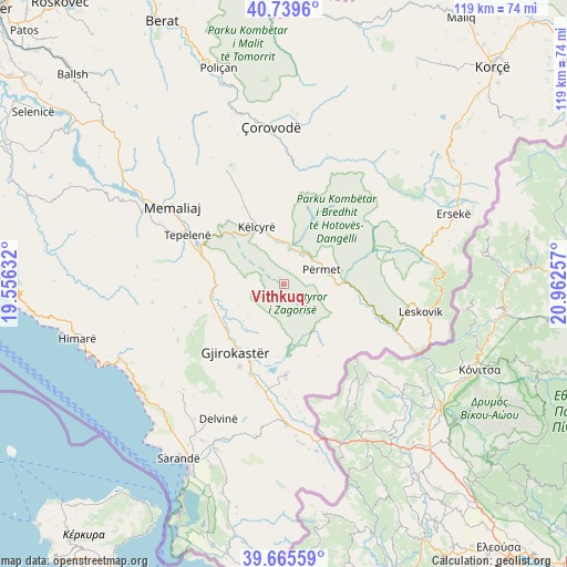
Vithkuq GPS coordinates[2]
40° 12' 16.992" North, 20° 15' 33.984" East
| Map corner | latitude | longitude |
|---|---|---|
| Upper-left | 40.7396°, | 19.55632° |
| Center: | 40.20472°, | 20.25944° |
| Lower-right: | 39.66559°, | 20.96257° |
| Map W x H: | 119.4×119.4 km | = 74.2×74.2mi |
| max Lat: | 42.45139° ⇑92.4% North |
| Vithkuq: | 40.20472° |
| min Lat: | ⇓7.6% South 39.65889° |
| min Long | Vithkuq | max Long |
| 19.40556° | 20.25944° | 20.99° |
| W 73%⇐ | ⇒27% E |
Elevation
Elevation of Vithkuq is 675 m = 2215 ft, and this is 300.4 m = 986 ft above average elevation for this country.
| Max E: |
1352 m = 4436 ft | 24.8% |
| Vithkuq | 675 m 2215 ft | |
| Avg. | 374.6 m = 1229 ft | |
Min E: |
-2 m = -7 ft | 75.2% |
See also: Albania elevation on elevation.city.
Geographical zone
Vithkuq is located in North temperate zone (between Tropic of Cancer and the Arctic Circle). Distance of this Northern Tropic circle is 1864.4 km =1158.5 mi to South.| Distance of | km | miles | from Vithkuq |
|---|---|---|---|
| North Pole | 5536.7 | 3440.3 | to North |
| Arctic Circle | 2930.8 | 1821.1 | to North |
| Tropic Cancer | 1864.4 | 1158.5 | to South |
| Equator | 4470.3 | 2777.7 | to South |


Nearby cities:
15 places around Vithkuq: (largest is in red/bold)
• Gjinkar
12.5 km =7.8 mi,  92°
92°
• Gjirokastër
17.6 km =10.9 mi,  215°
215°
• Këlcyrë
13.4 km =8.3 mi,  333°
333°
• Lazarat
20 km =12.4 mi,  208°
208°
• Libohovë
19.3 km =12 mi,  179°
179°
• Odrie
11.2 km =7 mi, 224°
• Petran
13.5 km =8.4 mi, 87°
• Picar
18.4 km =11.4 mi,  256°
256°
• Piskovë
8.4 km =5.2 mi,  7°
7°
• Përmet
8.5 km =5.3 mi,  67°
67°
• Qestorat
10.9 km =6.8 mi, 207°
• Saraqinishtë
11.3 km =7 mi,  192°
192°
• Skore
14.1 km =8.8 mi,  140°
140°
• Sukë
20.9 km =13 mi, 334°
• Topojan
19.6 km =12.2 mi,  348°
348°
Sources, notices
• [Note1] Compared only with cities in Albania existing in our database
• [Src1] Map data: © OpenStreetMap contributors (CC-BY-SA)
• [Src2] Other city data from geonames.org with taken over terms of usage.
• [Src3] Geographical zone / Annual Mean Temperature by Robert A. Rohde @ Wikipedia
