Picar geodata
Picar (Gjirokastër) is a seat of a third-order administrative division; located in Albania in Europe/Tirane (GMT+2) time zone. In our database, there are 71 cities with bigger population. Compared to other cities in Albania, 93% of cities are located further ↑North; 55.5% of cities are located further ←West and 51% of cities have lower elevation than Picar. Note1


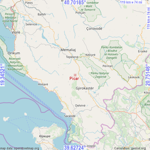
Picar GPS coordinates[2]
40° 10' 0.012" North, 20° 2' 53.988" East
| Map corner | latitude | longitude |
|---|---|---|
| Upper-left | 40.70185°, | 19.34521° |
| Center: | 40.16667°, | 20.04833° |
| Lower-right: | 39.62724°, | 20.75146° |
| Map W x H: | 119.5×119.5 km | = 74.3×74.3mi |
| max Lat: | 42.45139° ⇑93% North |
| Picar: | 40.16667° |
| min Lat: | ⇓7% South 39.65889° |
| min Long | Picar | max Long |
| 19.40556° | 20.04833° | 20.99° |
| W 55.5%⇐ | ⇒44.5% E |
Elevation
Elevation of Picar is 295 m = 968 ft, and this is 79.6 m = 261 ft below average elevation for this country.
| Max E: |
1352 m = 4436 ft | 49% |
| Avg. | 374.6 m = 1229 ft | |
| Picar | 295 m = 968 ft | |
Min E: |
-2 m = -7 ft | 51% |
See also: Albania elevation on elevation.city.
Geographical zone
Picar is located in North temperate zone (between Tropic of Cancer and the Arctic Circle). Distance of this Northern Tropic circle is 1860.2 km =1155.9 mi to South.| Distance of | km | miles | from Picar |
|---|---|---|---|
| North Pole | 5540.9 | 3443 | to North |
| Arctic Circle | 2935.1 | 1823.8 | to North |
| Tropic Cancer | 1860.2 | 1155.9 | to South |
| Equator | 4466.1 | 2775.1 | to South |


Nearby cities:
15 places around Picar: (largest is in red/bold)
• Gjirokastër
12.7 km =7.9 mi,  142°
142°
• Kardhiq
5.3 km =3.3 mi,  199°
199°
• Këlcyrë
20.2 km =12.6 mi,  36°
36°
• Lazarat
15.8 km =9.8 mi,  147°
147°
• Libohovë
23.7 km =14.7 mi,  129°
129°
• Lukovë
22.5 km =14 mi,  210°
210°
• Memaliaj
21.4 km =13.3 mi,  344°
344°
• Odrie
10.7 km =6.6 mi,  110°
110°
• Piskovë
22.8 km =14.2 mi,  56°
56°
• Progonat
10.2 km =6.3 mi,  300°
300°
• Qestorat
14 km =8.7 mi, 113°
• Saraqinishtë
16.8 km =10.4 mi, 113°
• Tepelenë
14.6 km =9.1 mi,  350°
350°
• Vergo
18.1 km =11.2 mi,  190°
190°
• Vithkuq
18.4 km =11.4 mi,  76°
76°
Sources, notices
• [Note1] Compared only with cities in Albania existing in our database
• [Src1] Map data: © OpenStreetMap contributors (CC-BY-SA)
• [Src2] Other city data from geonames.org with taken over terms of usage.
• [Src3] Geographical zone / Annual Mean Temperature by Robert A. Rohde @ Wikipedia
