Ujmisht geodata
Ujmisht (Kukës) is a seat of a third-order administrative division; located in Albania in Europe/Tirane (GMT+2) time zone. In our database, there are 71 cities with bigger population. Compared to other cities in Albania, 86.8% of cities are located further ↓South; 78.9% of cities are located further ←West and 71% of cities have lower elevation than Ujmisht. Note1


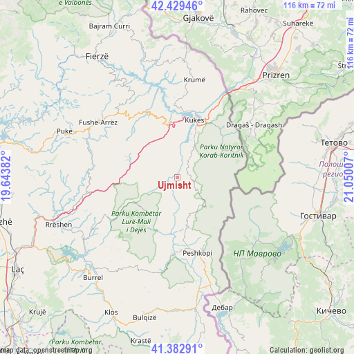
Ujmisht GPS coordinates[2]
41° 54' 29.988" North, 20° 20' 48.984" East
| Map corner | latitude | longitude |
|---|---|---|
| Upper-left | 42.42946°, | 19.64382° |
| Center: | 41.90833°, | 20.34694° |
| Lower-right: | 41.38291°, | 21.05007° |
| Map W x H: | 116.4×116.4 km | = 72.3×72.3mi |
| max Lat: | 42.45139° ⇑13.2% North |
| Ujmisht: | 41.90833° |
| min Lat: | ⇓86.8% South 39.65889° |
| min Long | Ujmisht | max Long |
| 19.40556° | 20.34694° | 20.99° |
| W 78.9%⇐ | ⇒21.1% E |
Elevation
Elevation of Ujmisht is 594 m = 1949 ft, and this is 219.4 m = 720 ft above average elevation for this country.
| Max E: |
1352 m = 4436 ft | 29% |
| Ujmisht | 594 m 1949 ft | |
| Avg. | 374.6 m = 1229 ft | |
Min E: |
-2 m = -7 ft | 71% |
See also: Albania elevation on elevation.city.
Geographical zone
Ujmisht is located in North temperate zone (between Tropic of Cancer and the Arctic Circle). Distance of this Northern Tropic circle is 2053.9 km =1276.2 mi to South.| Distance of | km | miles | from Ujmisht |
|---|---|---|---|
| North Pole | 5347.3 | 3322.7 | to North |
| Arctic Circle | 2741.4 | 1703.4 | to North |
| Tropic Cancer | 2053.9 | 1276.2 | to South |
| Equator | 4659.8 | 2895.5 | to South |


Nearby cities:
15 places around Ujmisht: (largest is in red/bold)
• Arras
19.3 km =12 mi,  185°
185°
• Arrën
4.9 km =3 mi,  276°
276°
• Bicaj
11 km =6.8 mi,  29°
29°
• Bushtricë
7 km =4.3 mi,  118°
118°
• Fushë-Lurë
14.8 km =9.2 mi,  219°
219°
• Fushë-Çidhnë
16.4 km =10.2 mi,  181°
181°
• Kalis
7.9 km =4.9 mi,  168°
168°
• Kokaj
13.5 km =8.4 mi,  104°
104°
• Kolsh
18.9 km =11.7 mi,  358°
358°
• Shtiqën
16.4 km =10.2 mi, 26°
• Shëngjin
13.3 km =8.3 mi, 278°
• Sllovë
13 km =8.1 mi,  156°
156°
• Surroj
9.3 km =5.8 mi, 358°
• Zall-Dardhë
11.3 km =7 mi, 184°
• Zall-Reç
4.2 km =2.6 mi,  211°
211°
Sources, notices
• [Note1] Compared only with cities in Albania existing in our database
• [Src1] Map data: © OpenStreetMap contributors (CC-BY-SA)
• [Src2] Other city data from geonames.org with taken over terms of usage.
• [Src3] Geographical zone / Annual Mean Temperature by Robert A. Rohde @ Wikipedia
