Shëngjin geodata
Shëngjin (Lezhë) is a seat of a third-order administrative division; located in Albania in Europe/Tirane (GMT+2) time zone. In our database, there are 71 cities with bigger population. Compared to other cities in Albania, 87.6% of cities are located further ↓South; 67% of cities are located further ←West and 91.8% of cities have lower elevation than Shëngjin. Note1


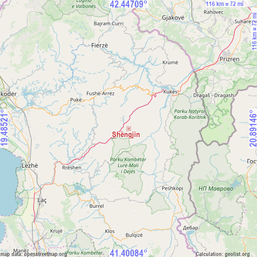
Shëngjin GPS coordinates[2]
41° 55' 33.996" North, 20° 11' 17.988" East
| Map corner | latitude | longitude |
|---|---|---|
| Upper-left | 42.44709°, | 19.48521° |
| Center: | 41.92611°, | 20.18833° |
| Lower-right: | 41.40084°, | 20.89146° |
| Map W x H: | 116.3×116.3 km | = 72.3×72.3mi |
| max Lat: | 42.45139° ⇑12.4% North |
| Shëngjin: | 41.92611° |
| min Lat: | ⇓87.6% South 39.65889° |
| min Long | Shëngjin | max Long |
| 19.40556° | 20.18833° | 20.99° |
| W 67%⇐ | ⇒33% E |
Elevation
Elevation of Shëngjin is 916 m = 3005 ft, and this is 541.4 m = 1776 ft above average elevation for this country.
| Max E: |
1352 m = 4436 ft | 8.2% |
| Shëngjin | 916 m 3005 ft | |
| Avg. | 374.6 m = 1229 ft | |
Min E: |
-2 m = -7 ft | 91.8% |
See also: Albania elevation on elevation.city.
Geographical zone
Shëngjin is located in North temperate zone (between Tropic of Cancer and the Arctic Circle). Distance of this Northern Tropic circle is 2055.8 km =1277.4 mi to South.| Distance of | km | miles | from Shëngjin |
|---|---|---|---|
| North Pole | 5345.3 | 3321.4 | to North |
| Arctic Circle | 2739.4 | 1702.2 | to North |
| Tropic Cancer | 2055.8 | 1277.4 | to South |
| Equator | 4661.7 | 2896.6 | to South |


Nearby cities:
15 places around Shëngjin: (largest is in red/bold)
• Arrën
8.4 km =5.2 mi,  99°
99°
• Bicaj
20 km =12.4 mi,  67°
67°
• Blinisht
17.2 km =10.7 mi,  245°
245°
• Bushtricë
20 km =12.4 mi,  105°
105°
• Fushë-Lurë
13.8 km =8.6 mi,  164°
164°
• Gjegjan
14.7 km =9.1 mi,  275°
275°
• Kalis
17.7 km =11 mi,  123°
123°
• Kthella e Epërme
16.6 km =10.3 mi,  220°
220°
• Kurbnesh
18.4 km =11.4 mi,  208°
208°
• Orosh
13.5 km =8.4 mi, 220°
• Shënmëri
20.2 km =12.6 mi,  11°
11°
• Surroj
14.8 km =9.2 mi,  60°
60°
• Ujmisht
13.3 km =8.3 mi, 98°
• Zall-Dardhë
18.1 km =11.2 mi,  137°
137°
• Zall-Reç
12.2 km =7.6 mi, 117°
Sources, notices
• [Note1] Compared only with cities in Albania existing in our database
• [Src1] Map data: © OpenStreetMap contributors (CC-BY-SA)
• [Src2] Other city data from geonames.org with taken over terms of usage.
• [Src3] Geographical zone / Annual Mean Temperature by Robert A. Rohde @ Wikipedia
