Progër geodata
Progër (Korçë) is a seat of a third-order administrative division; located in Albania in Europe/Tirane (GMT+2) time zone. In our database, there are 71 cities with bigger population. Compared to other cities in Albania, 73.2% of cities are located further ↑North; 99.7% of cities are located further ←West and 87.6% of cities have lower elevation than Progër. Note1


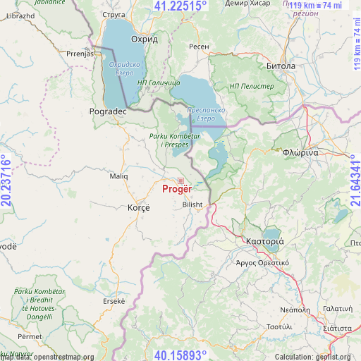
Progër GPS coordinates[2]
40° 41' 39.012" North, 20° 56' 25.008" East
| Map corner | latitude | longitude |
|---|---|---|
| Upper-left | 41.22515°, | 20.23716° |
| Center: | 40.69417°, | 20.94028° |
| Lower-right: | 40.15893°, | 21.64341° |
| Map W x H: | 118.6×118.6 km | = 73.7×73.7mi |
| max Lat: | 42.45139° ⇑73.2% North |
| Progër: | 40.69417° |
| min Lat: | ⇓26.8% South 39.65889° |
| min Long | Progër | max Long |
| 19.40556° | 20.94028° | 20.99° |
| W 99.7%⇐ | ⇒0.3% E |
Elevation
Elevation of Progër is 842 m = 2762 ft, and this is 467.4 m = 1533 ft above average elevation for this country.
| Max E: |
1352 m = 4436 ft | 12.4% |
| Progër | 842 m 2762 ft | |
| Avg. | 374.6 m = 1229 ft | |
Min E: |
-2 m = -7 ft | 87.6% |
See also: Albania elevation on elevation.city.
Geographical zone
Progër is located in North temperate zone (between Tropic of Cancer and the Arctic Circle). Distance of this Northern Tropic circle is 1918.8 km =1192.3 mi to South.| Distance of | km | miles | from Progër |
|---|---|---|---|
| North Pole | 5482.3 | 3406.5 | to North |
| Arctic Circle | 2876.4 | 1787.3 | to North |
| Tropic Cancer | 1918.8 | 1192.3 | to South |
| Equator | 4524.8 | 2811.6 | to South |


Nearby cities:
15 places around Progër: (largest is in red/bold)
• Bilisht
8.5 km =5.3 mi,  150°
150°
• Dishnicë
11.7 km =7.3 mi,  245°
245°
• Drenovë
17.5 km =10.9 mi,  225°
225°
• Hoçisht
9.8 km =6.1 mi,  192°
192°
• Korçë
15.9 km =9.9 mi,  238°
238°
• Libonik
19.6 km =12.2 mi,  273°
273°
• Liqenas
10.8 km =6.7 mi,  342°
342°
• Maliq
20.3 km =12.6 mi, 273°
• Mborje
15.4 km =9.6 mi, 228°
• Miras
20.6 km =12.8 mi,  182°
182°
• Mollaj
22.5 km =14 mi, 228°
• Novoselë
21.7 km =13.5 mi,  290°
290°
• Pirg
22.2 km =13.8 mi,  297°
297°
• Pojan
9.4 km =5.8 mi, 292°
• Vreshtas
17.9 km =11.1 mi,  309°
309°
Sources, notices
• [Note1] Compared only with cities in Albania existing in our database
• [Src1] Map data: © OpenStreetMap contributors (CC-BY-SA)
• [Src2] Other city data from geonames.org with taken over terms of usage.
• [Src3] Geographical zone / Annual Mean Temperature by Robert A. Rohde @ Wikipedia
